1980s Maps of Granville, Arizona
Explore 2 historic maps of Granville from the 1980s. These maps offer a rare glimpse into what life looked like during the 1980s — showing old roads, neighborhoods, homes, and landmarks that have changed or disappeared over time.
Whether you're researching your family's past, planning a metal detecting trip, or studying how Granville's landscape evolved across the 1980s, these high-resolution maps are a powerful tool for exploring the history of this region.
- Focus on a specific era: All maps on this page are from the 1980s, giving you a focused view of this time period.
- See what’s changed: Compare century-old streets, trails, and buildings to today's modern landscape using overlays and satellite layers.
- Research with precision: Use these maps for genealogy, historical research, land use analysis, or educational projects.
- View, download, or print: Maps are fully viewable online in high resolution, and can be downloaded or printed for your own records.
Start exploring Granville's history through authentic maps from the 1980s. This is your window into the past.
Granville, AZ maps
(2)- 1986 Map of Clifton, 1987 Print
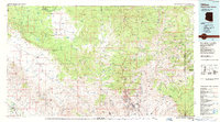 1986 Clifton1987 Print · USGSArizona's copper country and the rugged borderlands come into sharp focus in the mid-1980s. Researchers can trace the massive Morenci Open Pit and its rail connections to Clifton, alongside remote outposts like Point of Pines and Fort Thomas.2 unique versions available
 - 1989 Map of Coronado Mountain, 1990 Print
 1989 Coronado Mountain1990 Print · USGSGreenlee County high country is shown at the end of the eighties, straddling the San Carlos Indian Reservation line. Researchers can trace remote mining and water sites like the Crystal Cave Prospect, Sawmill Spring, and Willow Tank.
End of results
Showing maps 1-2 of 2
Top cities near Granville
Frequently asked questions
- What are the different types of historical maps available for Granville?
- What is the oldest map of Granville?
- Where can I purchase historical maps of Granville for my home or office?
- Where can I download high-res historical maps of Granville?
- Are there historical topographic maps available for Granville?
- Is there historical aerial imagery available for Granville?
- Where are historical maps of Granville sourced from?