Old Maps of Granville, Arizona for Metal Detecting
Plan your next treasure hunt with 16 historic maps of Granville. Find old homesites, ghost towns, trails, and gathering spots that may be lost to time — perfect for identifying promising metal detecting locations.
- Locate forgotten sites: Uncover places like long-lost settlements, abandoned rail lines, or gathering spots.
- Plan better hunts: Use map overlays combined with LiDAR or satellite views to narrow in on historically rich areas.
- Made for detectorists: Thousands of hobbyists use these maps to discover relics, coins, and hidden history.
Use these historic maps to boost your research and find new opportunities beneath the surface of Granville.
Granville, AZ maps
(16)- 1902 Map of Clifton
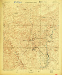 1902 Clifton1902 Print · USGSMining and rail history converge in this 1902 portrait of the Arizona Territory's copper belt. Researchers can trace the industrial layout of Morenci and Clifton, identifying the routes of the Coronado RR and the specialized King Incline.3 unique versions available
 - 1913 Map of Morenci, 1954 Print
 1913 Morenci1954 Print · USGSArizona's copper country and high timberlands meet in this pre-war survey of the Morenci district and Apache National Forest. Researchers can trace the early industrial footprint of Morenci and Clifton or find family landmarks like Miller Cabin and Cooks Ranch.2 unique versions available
 - 1915 Map of Morenci
 1915 Morenci1915 Print · USGSGreenlee County during the early 1900s shows a landscape defined by industrial copper mining and isolated high-desert ranching. Genealogists and historians can trace family locations from the Eagle Creek School to historic homesteads like Dudley Ranch and the settlement of Oroville.3 unique versions available
 - 1954 Map of Clifton, 1968 Print
 1954 Clifton1968 Print · USGSThe high timber and copper country of the Arizona-New Mexico border is captured here during the mid-fifties. Genealogists and historians can trace family holdings like the Double Circle Ranch or study the industrial footprint of the Smelting Plant at Clifton.3 unique versions available
 - 1957 Map of Clifton
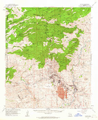
 1957 Clifton1957 Print · USGSThe copper-mining district around Clifton and Morenci meets the high timberlands of the Mogollon Rim during the mid-1950s. Genealogists and researchers can trace family-named outposts and remote mountain settlements like Reserve, Stargo, and Fort Thomas.
 - 1958 Map of Clifton
 1958 Clifton1958 Print · USGSThe rugged high country of the Arizona-New Mexico border comes into focus in the mid-fifties, showing a landscape of mining camps and forest outposts. Genealogists and researchers can trace old settlements and remote sites like Mogollon, East Fork Mission, and the Tidwell Mine.
 - 1962 Map of Clifton
 1962 Clifton1962 Print · USGSThe copper-rich Arizona-New Mexico borderlands come into focus in the early sixties, centered on the mining complexes of Morenci and Clifton. Researchers can trace the Southern Pacific rail lines and locate remote outposts like Honeymoon and the Double Circle Ranch.
 - 1962 Map of Clifton, 1964 Print
 1962 Clifton1964 Print · USGSMining and industry define this corner of Greenlee County in the early sixties, as the copper economy reshaped the Arizona landscape. Genealogists and historians can trace company housing at Plantsite, the massive Morenci Open Pit, and the former town of Metcalf.2 unique versions available
 - 1986 Map of Clifton, 1987 Print
 1986 Clifton1987 Print · USGSArizona's copper country and the rugged borderlands come into sharp focus in the mid-1980s. Researchers can trace the massive Morenci Open Pit and its rail connections to Clifton, alongside remote outposts like Point of Pines and Fort Thomas.2 unique versions available
 - 1989 Map of Coronado Mountain, 1990 Print
 1989 Coronado Mountain1990 Print · USGSGreenlee County high country is shown at the end of the eighties, straddling the San Carlos Indian Reservation line. Researchers can trace remote mining and water sites like the Crystal Cave Prospect, Sawmill Spring, and Willow Tank.
 - 1997 Map of Coronado Mountain, 2000 Print
 1997 Coronado Mountain2000 Print · USGSThe high country of Greenlee County is captured here in the late nineties, showcasing the interface between ranching outposts and wilderness. Researchers can trace the water infrastructure of Deerhead Ranch and the remote settlement at Granville.
 - 2011 Map of Coronado Mountain, 2011 Print
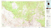
 2011 Coronado Mountain2011 Print · USGSCovers Granville, including Spur Cross, Graham County, and other nearby areas
 - 2014 Map of Coronado Mountain, 2014 Print
 2014 Coronado Mountain2014 Print · USGSCovers Granville, including Spur Cross, Graham County, and other nearby areas
 - 2018 Map of Coronado Mountain, 2018 Print
 2018 Coronado Mountain2018 Print · USGSCovers Granville, including Spur Cross, Graham County, and other nearby areas
 - 2021 Map of Coronado Mountain, 2021 Print
 2021 Coronado Mountain2021 Print · USGSThe high peaks of the Apache National Forest in Greenlee County come alive in this modern survey of the Arizona wilderness. Researchers can trace the trails and water sources that define this landscape, from the settlement of Granville to landmarks like Coronado Mtn and Wagon Spring.
 - 2026 Map of Coronado Mountain, 2026 Print
 2026 Coronado Mountain2026 Print · USGSCovers Granville, including Spur Cross, Graham County, and other nearby areas
End of results
Showing maps 1-16 of 16
Top cities near Granville
Frequently asked questions
- What are the different types of historical maps available for Granville?
- What is the oldest map of Granville?
- Where can I purchase historical maps of Granville for my home or office?
- Where can I download high-res historical maps of Granville?
- Are there historical topographic maps available for Granville?
- Is there historical aerial imagery available for Granville?
- Where are historical maps of Granville sourced from?