1900s (20th Century) Maps of Poston, Arizona
Explore 11 historic maps of Poston from the 1900s (20th Century). These maps offer a rare glimpse into what life looked like during the 1900s — showing old roads, neighborhoods, homes, and landmarks that have changed or disappeared over time.
Whether you're researching your family's past, planning a metal detecting trip, or studying how Poston's landscape evolved across the 1900s, these high-resolution maps are a powerful tool for exploring the history of this region.
- Focus on a specific era: All maps on this page are from the 1900s, giving you a focused view of this time period.
- See what’s changed: Compare century-old streets, trails, and buildings to today's modern landscape using overlays and satellite layers.
- Research with precision: Use these maps for genealogy, historical research, land use analysis, or educational projects.
- View, download, or print: Maps are fully viewable online in high resolution, and can be downloaded or printed for your own records.
Start exploring Poston's history through authentic maps from the 1900s. This is your window into the past.
Poston, AZ maps
(11)- 1931 Map of Moon Mtn, 1955 Print
 1931 Moon Mtn1955 Print · USGSThe Arizona-California borderlands are captured here in the early thirties, defined by the winding Colorado River and the stark Dome Rock Mountains. Historians and prospectors can trace mineral workings at the Valenzuella Mine and Mammoth Mine.2 unique versions available
 - 1932 Map of Moon Mtn
 1932 Moon Mtn1932 Print · USGSThe Arizona-California borderlands are captured here in the early 1930s, showing the intersection of tribal lands and desert mining. Genealogists and historians can trace the early boundaries of the Colorado River Indian Reservation and locate industrial sites like the Valenzuela Mine.2 unique versions available
 - 1942 Map of Blythe
 1942 Blythe1942 Print · USGSThe Lower Colorado River valley appears here in the early 1940s, showcasing the agricultural development of the Palo Verde Mesa alongside a booming mining industry. Researchers can locate remote desert outposts and extraction sites like Midland, the U S Gypsum Mine, and Nortons Landing.2 unique versions available
 - 1942 Map of MOON MTN, 1943 Print
 1942 MOON MTN1943 Print · USGSThe Colorado River valley and its surrounding desert ranges are shown here during the height of the Second World War. Historians can trace the locations of the Parker Alien Reception Center units and former workings at Valenzuella Mines.
 - 1954 Map of Salton Sea
 1954 Salton Sea1954 Print · USGSThe Colorado River and Imperial Valley desert frontiers are captured here in the 1950s. Trace the irrigation networks of Calipatria and mining sites like Eagle Mountain Mine.
 - 1955 Map of Salton Sea
 1955 Salton Sea1955 Print · USGSThe Colorado River and Imperial Valley desert basins appear here during the mid-fifties, revealing a landscape of remote mines and agricultural irrigation. Genealogists and researchers can trace locations like the Parker Alien Reception Center Unit No 1, Blythe, and the Kane Springs School.2 unique versions available
 - 1955 Map of Poston, 1956 Print
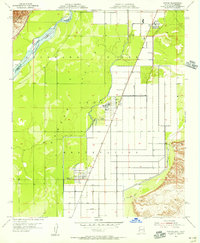 1955 Poston1956 Print · USGSThe Colorado River Valley in the mid-1950s reveals a highly organized landscape of irrigation and resettlement within the Colorado River Indian Reservation. Researchers can trace the civic layout of Poston and Poston 2 or follow water routes like the Main Drain.3 unique versions available
 - 1959 Map of Salton Sea, 1968 Print
 1959 Salton Sea1968 Print · USGSThe Colorado River and Salton Sea basin are shown here during a decade of intense military and agricultural activity. Trace family roots in Blythe or Niland, and locate historical mining operations like the Eagle Mountain Mine and Red Cloud Mine.4 unique versions available
 - 1963 Map of Salton Sea
 1963 Salton Sea1963 Print · USGSThe Colorado Desert during the early sixties shows a landscape defined by massive water projects and Cold War military ranges. Trace the growth of Salton City and Brawley, or locate remote desert outposts like the Paymaster Mine and Desert Center.
 - 1965 Map of Salton Sea
 1965 Salton Sea1965 Print · USGSThe Colorado Desert and Imperial Valley are caught in a period of intense irrigation and military expansion during the mid-sixties. Researchers can trace the desert's industrial footprint through the Eagle Mountain Mine, the remote Desert Center, and the Salton Sea Test Base.
 - 1986 Map of Blythe
 1986 Blythe1986 Print · USGSThe Colorado River valley at the California and Arizona border in the mid-1980s shows a landscape of intensive desert farming and remote mining. Trace the rail lines of the Atchison Topeka and Santa Fe or locate historical workings like the Arlington Mine and Victor Mine.3 unique versions available
End of results
Showing maps 1-11 of 11
Top cities near Poston
- Parker historical maps
- Parker historical maps
- Cienega Springs historical maps
- Big River historical maps
- Bluewater historical maps
- Parker Strip historical maps
See more
Frequently asked questions
- What are the different types of historical maps available for Poston?
- What is the oldest map of Poston?
- Where can I purchase historical maps of Poston for my home or office?
- Where can I download high-res historical maps of Poston?
- Are there historical topographic maps available for Poston?
- Is there historical aerial imagery available for Poston?
- Where are historical maps of Poston sourced from?