1970s Maps of Chandler, Arizona
Explore 4 historic maps of Chandler from the 1970s. These maps offer a rare glimpse into what life looked like during the 1970s — showing old roads, neighborhoods, homes, and landmarks that have changed or disappeared over time.
Whether you're researching your family's past, planning a metal detecting trip, or studying how Chandler's landscape evolved across the 1970s, these high-resolution maps are a powerful tool for exploring the history of this region.
- Focus on a specific era: All maps on this page are from the 1970s, giving you a focused view of this time period.
- See what’s changed: Compare century-old streets, trails, and buildings to today's modern landscape using overlays and satellite layers.
- Research with precision: Use these maps for genealogy, historical research, land use analysis, or educational projects.
- View, download, or print: Maps are fully viewable online in high resolution, and can be downloaded or printed for your own records.
Start exploring Chandler's history through authentic maps from the 1970s. This is your window into the past.
Chandler, AZ maps
(4)- 1971 Map of Gila Butte, 1972 Print
 1971 Gila Butte1972 Print · USGSThe Pinal County desert floor meets irrigated agriculture in the early 1970s, as seen from high-altitude aerial photography. Trace the rural layout of Ocotillo and Bapchule, or locate the prominent landmark of Gila Butte overlooking the Gila River.
 - 1971 Map of Chandler, 1972 Print
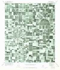 1971 Chandler1972 Print · USGSMaricopa County is captured during its mid-century agricultural prime before the surge of suburban sprawl. Researchers can trace the early layouts of Chandler and Gilbert alongside vital irrigation routes like the Eastern Canal.
 - 1971 Map of Guadalupe, 1972 Print
 1971 Guadalupe1972 Print · USGSMaricopa County agriculture and rural life are captured in the early seventies before the surge of desert suburbanization. Genealogists and local researchers can trace the early footprints of Guadalupe and the farming settlements at Kyrene and Hightown.
 - 1971 Map of Gila Butte NW, 1972 Print
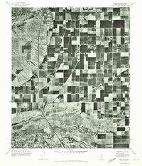
 1971 Gila Butte NW1972 Print · USGSPinal and Maricopa counties appear in the early 1970s as a study in desert irrigation and military aviation. Researchers can trace the agricultural footprint around Bapchule, the natural course of the Gila River, and the Goodyear Air Force Auxiliary Airfield.
End of results
Showing maps 1-4 of 4
Top cities near Chandler
- Phoenix historical maps
- Mesa historical maps
- Scottsdale historical maps
- Gilbert historical maps
- Tempe historical maps
- Maricopa historical maps
See more
Top neighborhoods of Chandler
- West Chandler historical maps
- Serape historical maps
- Sunbird Golf Resort historical maps
- Crestview Chateaux historical maps
- Carrizal historical maps
- Hightown historical maps
See more
Frequently asked questions
- What are the different types of historical maps available for Chandler?
- What is the oldest map of Chandler?
- Where can I purchase historical maps of Chandler for my home or office?
- Where can I download high-res historical maps of Chandler?
- Are there historical topographic maps available for Chandler?
- Is there historical aerial imagery available for Chandler?
- Where are historical maps of Chandler sourced from?