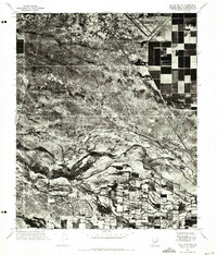
1971 Map of Gila Butte NW
USGS Topo · Published 1972About this map
Agricultural fields in the Gila River Indian Community meet the arid desert terrain of Central Arizona in this 1971 orthophotomosaic. The settlement of Bapchule sits in the lower portion of the sheet, surrounded by a complex network of irrigated farmland that contrasts sharply with the winding, braided channel of the Gila River. This imagery provides a distinct visual record of land use, where the geometric precision of human cultivation abruptly transitions into the natural drainage patterns of the desert. In the upper right, the Goodyear Air Force Auxiliary Airfield appears as a stark, cleared geometric form, reflecting the military's aviation footprint in the region during the early 1970s. The map captures the delicate balance between the riparian zone and the expanding agricultural developments of Pinal and Maricopa counties.
Find a feature on this map
3 named features on this map. Tap any name to fly to it.
Don’t see what you’re looking for? This feature index may not catch every label — zoom into the map to look around manually.
Map Details
Editions of this 1971 Gila Butte NW Map
This is the sole edition of this map. No revisions or reprints were ever made.
Other maps of this area

1912 · Phoenix
USGS Topo · 1:62,500

1913 · Mesa
USGS Topo · 1:62,500

1913 · Maricopa
USGS Topo · 1:62,500

1914 · Gila Butte
USGS Topo · 1:62,500

1914 · Phoenix
USGS Topo · 1:62,500

1915 · Mesa
USGS Topo · 1:62,500

1915 · Maricopa
USGS Topo · 1:62,500

1917 · Gila Butte
USGS Topo · 1:62,500

1952 · Gila Butte SE
USGS Topo · 1:24,000

1952 · Maricopa
USGS Topo · 1:24,000