1950s Maps of Silva Mountain, Phoenix
Explore 6 historic maps of Silva Mountain from the 1950s. These maps offer a rare glimpse into what life looked like during the 1950s — showing old roads, neighborhoods, homes, and landmarks that have changed or disappeared over time.
Whether you're researching your family's past, planning a metal detecting trip, or studying how Silva Mountain's landscape evolved across the 1950s, these high-resolution maps are a powerful tool for exploring the history of this region.
- Focus on a specific era: All maps on this page are from the 1950s, giving you a focused view of this time period.
- See what’s changed: Compare century-old streets, trails, and buildings to today's modern landscape using overlays and satellite layers.
- Research with precision: Use these maps for genealogy, historical research, land use analysis, or educational projects.
- View, download, or print: Maps are fully viewable online in high resolution, and can be downloaded or printed for your own records.
Start exploring Silva Mountain's history through authentic maps from the 1950s. This is your window into the past.
Silva Mountain, Phoenix maps
(6)- 1952 Map of Lone Butte, 1957 Print
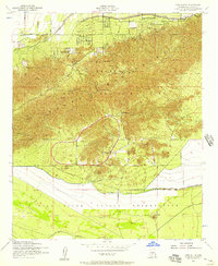 1952 Lone Butte1957 Print · USGSThe South Mountains meet the Gila River Indian Reservation in the early fifties, showing a desert landscape during a period of institutional growth. Trace the development of the Phoenix Proving Grounds, locate the Phoenix Police Academy, and find the isolated Lone Butte.5 unique versions available
 - 1952 Map of Phoenix, 1957 Print
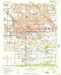 1952 Phoenix1957 Print · USGSPhoenix thrives in the early fifties as post-war growth transforms the Salt River Valley. Researchers can trace mid-century landmarks from Phoenix Municipal Airport to the historic Greenwood Cem and Encanto Park & Golf Course.5 unique versions available
 - 1952 Map of Phoenix, 1960 Print
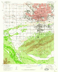 1952 Phoenix1960 Print · USGSCentral Arizona's desert valley is shown in the early fifties as the city expands toward the Salt River. Genealogists can trace family names and sites from Maricopa Village to Alhambra, including local landmarks like St Johns Indian Sch.2 unique versions available
 - 1954 Map of Phoenix, 1964 Print
 1954 Phoenix1964 Print · USGSMid-century Arizona is captured here as the Phoenix metropolitan area begins its rapid expansion into the surrounding desert. Genealogists and historians can trace the development of agricultural hubs like Buckeye and Tolleson, or locate remote landmarks like the Vulture Mine and Nottbusch Cem.5 unique versions available
 - 1957 Map of Phoenix
 1957 Phoenix1957 Print · USGSGreater Phoenix and the central Arizona desert during the mid-fifties reveal a landscape of growing suburbs and active desert mines. Researchers can trace the legacy of local landmarks like Wickenburg Prison, the Vulture Mine, and the Tonopah Post Office.
 - 1958 Map of Phoenix
 1958 Phoenix1958 Print · USGSThe Phoenix Valley enters a period of postwar expansion, where desert irrigation meets massive military aviation footprints. Trace the development of Phoenix and Glendale alongside the legendary Vulture Mine and the auxiliary runways of Luke Air Force Base.
End of results
Showing maps 1-6 of 6
Frequently asked questions
- What are the different types of historical maps available for Silva Mountain?
- What is the oldest map of Silva Mountain?
- Where can I purchase historical maps of Silva Mountain for my home or office?
- Where can I download high-res historical maps of Silva Mountain?
- Are there historical topographic maps available for Silva Mountain?
- Is there historical aerial imagery available for Silva Mountain?
- Where are historical maps of Silva Mountain sourced from?