1980s Maps of Kaibab, Arizona
Explore 13 historic maps of Kaibab from the 1980s. These maps offer a rare glimpse into what life looked like during the 1980s — showing old roads, neighborhoods, homes, and landmarks that have changed or disappeared over time.
Whether you're researching your family's past, planning a metal detecting trip, or studying how Kaibab's landscape evolved across the 1980s, these high-resolution maps are a powerful tool for exploring the history of this region.
- Focus on a specific era: All maps on this page are from the 1980s, giving you a focused view of this time period.
- See what’s changed: Compare century-old streets, trails, and buildings to today's modern landscape using overlays and satellite layers.
- Research with precision: Use these maps for genealogy, historical research, land use analysis, or educational projects.
- View, download, or print: Maps are fully viewable online in high resolution, and can be downloaded or printed for your own records.
Start exploring Kaibab's history through authentic maps from the 1980s. This is your window into the past.
Kaibab, AZ maps
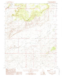
(13)- 1980 Map of Elephant Butte
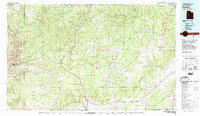
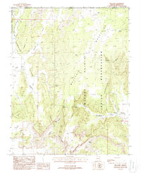
 1980 Elephant Butte1980 Print · USGSThe Utah and Arizona borderlands come into focus in the 1970s, showing a high-desert landscape divided by the Kaibab Indian Reservation Bdy. Researchers can locate vital water sources like Wyatt Spring and trace travel routes along a Jeep Trail through Elephant Gap.
 - 1980 Map of Kanab, 1981 Print
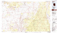
 1980 Kanab1981 Print · USGSSouthern Utah in the late seventies is a landscape of massive geologic terraces and isolated ranching towns. Trace the growth of Kanab and Springdale or locate vanished sites like Shunesburg among the White Cliffs and Vermilion Cliffs.
 - 1984 Map of Fredonia
 1984 Fredonia1984 Print · USGSThe Arizona Strip in the mid-1980s reveals a sparse network of settlements and vast public lands. Genealogists and historians can trace the foundations of Fredonia and Colorado City or locate landmarks like Pipe Spring National Monument.2 unique versions available
 - 1985 Map of Kanab
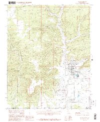 1985 Kanab1985 Print · USGSThe high desert landscape of the Utah-Arizona border comes into focus in the mid-1980s, centered on the settlement of Kanab. Researchers can trace the town's footprint, including the Cem, the Movie Set (Fort), and the rugged Vermilion Cliffs.2 unique versions available
 - 1985 Map of Yellowjacket Canyon
 1985 Yellowjacket Canyon1985 Print · USGSThe high deserts along the Utah-Arizona border are shown here in the mid-1980s, revealing a landscape of shifting dunes and deep canyons. Trace the boundaries of the Coral Pink Sand Dunes State Reserve and locate remote water sources like Yellowjacket Spring and Chris Spring.
 - 1988 Map of White Sage Flat
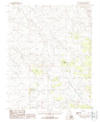 1988 White Sage Flat1988 Print · USGSCoconino County’s high desert plateau is shown during the late 1980s, revealing a landscape shaped by ranching and resource extraction. Researchers can locate remote infrastructure like the Rain Apron, early mining Prospects, and the drainage of Jacob Canyon.
 - 1988 Map of Moccasin
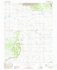
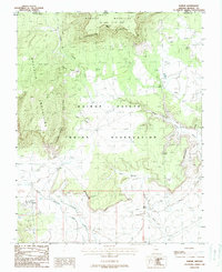
 1988 Moccasin1988 Print · USGSThe settlement of Moccasin and the Kaibab Indian Reservation are captured here in the late eighties as they existed within a landscape of dramatic sandstone plateaus. Researchers can locate the community's Cem, the local Rodeo Ground, and numerous named water sources like Meeks Spring.
 - 1988 Map of Pipe Spring
 1988 Pipe Spring1988 Print · USGSThe Arizona Strip in the late eighties reveals a landscape of high-desert springs and Indigenous lands north of the Grand Canyon. Researchers can trace the layout of Pipe Spring National Monument and locate remote features like Scotts Hole and Twomile Seep.
 - 1988 Map of Pipe Valley
 1988 Pipe Valley1988 Print · USGSHigh desert ranching and indigenous lands in Mohave County are captured here in the late eighties. Researchers can trace remote water sources and landmarks like Rouch Well, Moonshine Spring, and the unique Elephants Foot formation.
 - 1988 Map of Clear Water Spring
 1988 Clear Water Spring1988 Print · USGSThe Kaibab Indian Reservation in Northern Arizona is captured here during the late eighties, showcasing a landscape defined by vital springs and deep canyon washes. Researchers can trace the path of Kanab Creek or locate remote water sources like Clear Water Spring and Quickwater Spring.
 - 1988 Map of Shinarump Point
 1988 Shinarump Point1988 Print · USGSCoconino County's high desert plateaus are detailed here during the late eighties, showing a landscape defined by deep canyons and prominent points. Researchers can trace resource extraction and drainage patterns across Shinarump Point, Crowbar Point, and Wildcat Canyon.
 - 1988 Map of Fredonia
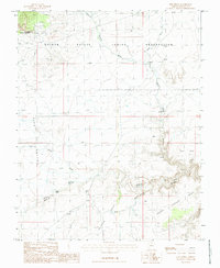
 1988 Fredonia1988 Print · USGSFredonia and the Kaibab Indian Reservation are documented here in the late eighties as the community expanded alongside the Shinarump Cliffs. Researchers can locate the local Cem, the Oil Refinery, and rural outposts like Sixmile Village.
 - 1988 Map of Kaibab, 1990 Print
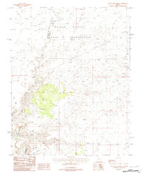
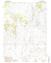
 1988 Kaibab1990 Print · USGSTribal lands on the Arizona-Utah border are shown here in the late eighties, centered on the settlement of Kaibab. Genealogists and local historians can locate the local Cem and trace important water sources like Clear Water Spring and Aulson Spring.
End of results
Showing maps 1-13 of 13
Top cities near Kaibab
Top neighborhoods of Kaibab
Frequently asked questions
- What are the different types of historical maps available for Kaibab?
- What is the oldest map of Kaibab?
- Where can I purchase historical maps of Kaibab for my home or office?
- Where can I download high-res historical maps of Kaibab?
- Are there historical topographic maps available for Kaibab?
- Is there historical aerial imagery available for Kaibab?
- Where are historical maps of Kaibab sourced from?