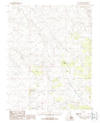
1988 Map of White Sage Flat
USGS Topo · Published 1988About this map
White Sage Flat dominates this high-altitude landscape in Northern Arizona, where drainage systems like Jacob Canyon and Wildcat Canyon carve through the terrain. The area reflects a land used for resource extraction and livestock management, as evidenced by several Gravel Pits and various mining Prospects. A long-distance Transmission Line cuts across the southeastern portion of the map, illustrating the infrastructure required to connect remote desert regions.
Find a feature on this map
12 named features on this map. Tap any name to fly to it.
Don’t see what you’re looking for? This feature index may not catch every label — zoom into the map to look around manually.
Map Details
Editions of this 1988 White Sage Flat Map
This is the sole edition of this map. No revisions or reprints were ever made.
Other maps of this area

1886 · Kaibab
USGS Topo · 1:250,000

1953 · Grand Canyon
USGS Topo · 1:250,000

1954 · Shinarump NW
USGS Topo · 1:24,000

1954 · Fredonia NE
USGS Topo · 1:24,000

1954 · Fredonia
USGS Topo · 1:62,500

1957 · Grand Canyon
USGS Topo · 1:250,000
1957 · Shinarump NE
USGS Topo · 1:24,000

1957 · Shinarump SE
USGS Topo · 1:24,000

1957 · Shinarump SW
USGS Topo · 1:24,000
1957 · Shinarump
USGS Topo · 1:62,500