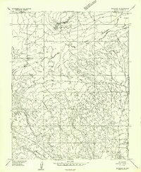
1957 Map of Shinarump NE
USGS Topo · Published 1958About this map
The Grand Canyon National Game Preserve anchors the southern portion of this high-desert survey, which documents the remote terrain where the Kaibab Plateau meets the Utah-Arizona state line. The landscape is defined by extensive drainage systems like Johnson Wash and Seaman Wash, which carve through the arid plateaus and canyons. Settlement is sparse, with the location at Ryan serving as a rare named landmark in an area otherwise dominated by seasonal water sources and natural features such as Johnson Spring and Buck Pasture Canyon.
Find a feature on this map
18 named features on this map. Tap any name to fly to it.
Don’t see what you’re looking for? This feature index may not catch every label — zoom into the map to look around manually.
Map Details
Editions of this 1957 Shinarump NE Map
This is the sole edition of this map. No revisions or reprints were ever made.
Other maps of this area

1886 · Kanab
USGS Topo · 1:250,000

1886 · Kaibab
USGS Topo · 1:250,000

1953 · Cedar City
USGS Topo · 1:250,000

1953 · Grand Canyon
USGS Topo · 1:250,000

1954 · Buckskin Gulch SW
USGS Topo · 1:24,000

1954 · Johnson SE
USGS Topo · 1:24,000

1954 · Shinarump NW
USGS Topo · 1:24,000

1954 · Johnson SW
USGS Topo · 1:24,000

1954 · Buckskin Gulch
USGS Topo · 1:62,500

1954 · Johnson
USGS Topo · 1:62,500