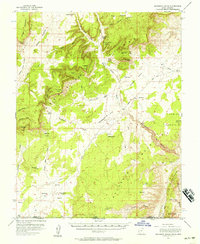
1954 Map of Buckskin Gulch
USGS Topo · Published 1957About this map
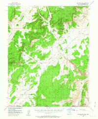
The remote high desert of southern Utah and northern Arizona is revealed in this mid-century topographic survey, focused on the dramatic transition from White Cliffs down to the Paria River drainage. Cattle ranching defines the scattered human presence in this arid landscape, evidenced by isolated outposts such as Clark Ranch, Jepson Ranch, and the School Section Ranch. The terrain is characterized by massive geographic features like Five Mile Mountain and the jagged uplift of The Cockscomb, with a complex network of seasonal washes including Petrified Hollow Wash and Seaman Wash carving through the plateaus. Transportation in the mid-1950s was limited to primitive roads and a Jeep Trail, illustrating the region's continued isolation even as modern surveying methods began to document its deep canyons and named landmarks like Buckskin Gulch and Fin Little Point.
Find a feature on this map
59 named features on this map. Tap any name to fly to it.
Don’t see what you’re looking for? This feature index may not catch every label — zoom into the map to look around manually.
Map Details
Editions of this 1954 Buckskin Gulch Map
3 editions found

Other maps of this area

1886 · Kanab
USGS Topo · 1:250,000

1886 · Escalante
USGS Topo · 1:250,000

1886 · Echo Cliffs
USGS Topo · 1:250,000

1886 · Kaibab
USGS Topo · 1:250,000

1891 · Echo Cliffs
USGS Topo · 1:250,000

1953 · Cedar City
USGS Topo · 1:250,000

1953 · Grand Canyon
USGS Topo · 1:250,000

1954 · Buckskin Gulch NW
USGS Topo · 1:24,000

1954 · Buckskin Gulch NE
USGS Topo · 1:24,000

1954 · Buckskin Gulch SE
USGS Topo · 1:24,000