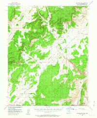
1954 Map of Buckskin Mtn
USGS Topo · Published 1964About this map
Buckskin Mountain dominates the high-desert terrain of the Utah-Arizona borderlands, appearing here as it was surveyed in the mid-1950s. The landscape is defined by the sharp geological uplift of The Cockscomb and the pale exposure of the White Cliffs, creating a remote expanse where water sources like Wildcat Spring and Kitchen Corral Spring were vital for the area's cattle operations. This survey, produced in cooperation with the Atomic Energy Commission, highlights a sparse settlement pattern of isolated outposts such as Clark Ranch and Jepson Ranch. The inclusion of School Section Ranch and a network of jeep trails across Telegraph Flat reflects the mid-century transition from traditional ranching to modern land management and mineral exploration in the White Sage region of Kane County.
Find a feature on this map
39 named features on this map. Tap any name to fly to it.
Don’t see what you’re looking for? This feature index may not catch every label — zoom into the map to look around manually.
Map Details
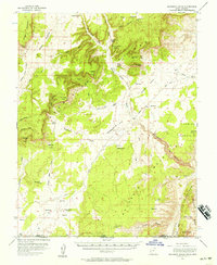
Editions of this 1954 Buckskin Mtn Map
3 editions found

Other maps of this area

1886 · Kanab
USGS Topo · 1:250,000

1886 · Escalante
USGS Topo · 1:250,000

1886 · Echo Cliffs
USGS Topo · 1:250,000

1886 · Kaibab
USGS Topo · 1:250,000

1891 · Echo Cliffs
USGS Topo · 1:250,000

1953 · Cedar City
USGS Topo · 1:250,000

1953 · Grand Canyon
USGS Topo · 1:250,000

1954 · Buckskin Gulch NW
USGS Topo · 1:24,000

1954 · Buckskin Gulch NE
USGS Topo · 1:24,000

1954 · Buckskin Gulch SE
USGS Topo · 1:24,000