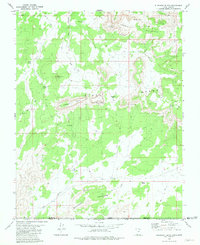
1980 Map of Elephant Butte
USGS Topo · Published 1980About this map
The Kaibab Indian Reservation Bdy cuts across the southern portion of this landscape, marking a significant jurisdictional boundary in the high desert of the Arizona-Utah borderlands. In this 1970s survey, the terrain is defined by dramatic escarpments and plateau features such as the White Cliffs and the Block White Cliffs. Named landmarks like Elephant Butte and Sandstone Butte rise above Oak Flat, providing distinct navigational points for those traversing the network of Jeep Trails. Water sources were critical to the livestock and settlement history of this arid region, evidenced by the scattered locations of Wyatt Spring, Kane Spring, and Pine Spring. The presence of a Seismometer near the Moccasin Mountains indicates the area's geological activity and scientific interest during the late twentieth century, while the Kane Co Mohave Co line underscores the political geography of this remote frontier.
Find a feature on this map
25 named features on this map. Tap any name to fly to it.
Don’t see what you’re looking for? This feature index may not catch every label — zoom into the map to look around manually.
Map Details
Editions of this 1980 Elephant Butte Map
This is the sole edition of this map. No revisions or reprints were ever made.
Other maps of this area

1886 · Kanab
USGS Topo · 1:250,000

1886 · Kaibab
USGS Topo · 1:250,000

1953 · Cedar City
USGS Topo · 1:250,000

1953 · Grand Canyon
USGS Topo · 1:250,000

1954 · Kanab SW
USGS Topo · 1:24,000

1954 · Fredonia NW
USGS Topo · 1:24,000
1954 · Short Creek NW
USGS Topo · 1:24,000

1954 · Fredonia
USGS Topo · 1:62,500

1954 · Short Creek
USGS Topo · 1:62,500
1956 · Springdale SE
USGS Topo · 1:24,000