
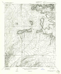
1954 Map of Kanab SW
USGS Topo · Published 1956About this map
Yellowjacket Spring and Harris Springs provide rare water sources across this high-desert landscape, where the topography transitions from deep canyon drainages to rolling dunes. Mapped in the mid-1950s along the Utah-Arizona border, this preliminary survey captures the rugged intersection of Kane County and Mohave County. The land is defined by sharp elevation shifts, particularly within Yellowjacket Canyon and Cottonwood Canyon, while the southwestern corner is dominated by shifting Sand Dunes and the seasonal path of Sandy Wash. This era of mapping utilized aerial photography to document the complex drainage systems of Indian Canyon and its South Fork, illustrating the remote character of the borderlands before modern infrastructure significantly altered local access.
Find a feature on this map
13 named features on this map. Tap any name to fly to it.
Don’t see what you’re looking for? This feature index may not catch every label — zoom into the map to look around manually.
Map Details
Editions of this 1954 Kanab SW Map
This is the sole edition of this map. No revisions or reprints were ever made.
Other maps of this area

1886 · Kanab
USGS Topo · 1:250,000

1886 · Kaibab
USGS Topo · 1:250,000

1953 · Cedar City
USGS Topo · 1:250,000

1953 · Grand Canyon
USGS Topo · 1:250,000

1954 · Fredonia NW
USGS Topo · 1:24,000

1954 · Kanab SE
USGS Topo · 1:24,000

1954 · Fredonia NE
USGS Topo · 1:24,000

1954 · Fredonia
USGS Topo · 1:62,500

1954 · Short Creek
USGS Topo · 1:62,500
1956 · Springdale SE
USGS Topo · 1:24,000