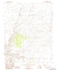
1988 Map of Clear Water Spring
USGS Topo · Published 1988About this map
The Kaibab - Paiute Indian Reservation dominates this 1980s landscape, where the high desert terrain is defined by deep drainages and vital water sources. The Kanab Creek system cuts through the region, joined by Sandy Canyon Wash and Bulrush Wash. This survey captures the area just as modern infrastructure began to intersect with long-established landmarks, visible in the presence of the Trans Line corridor crossing the plateau.
Find a feature on this map
14 named features on this map. Tap any name to fly to it.
Don’t see what you’re looking for? This feature index may not catch every label — zoom into the map to look around manually.
Map Details
Editions of this 1988 Clear Water Spring Map
This is the sole edition of this map. No revisions or reprints were ever made.
Other maps of this area

1886 · Kaibab
USGS Topo · 1:250,000

1953 · Grand Canyon
USGS Topo · 1:250,000

1954 · Fredonia NW
USGS Topo · 1:24,000

1954 · Shinarump NW
USGS Topo · 1:24,000

1954 · Fredonia SW
USGS Topo · 1:24,000

1954 · Fredonia NE
USGS Topo · 1:24,000

1954 · Fredonia
USGS Topo · 1:62,500

1957 · Grand Canyon
USGS Topo · 1:250,000

1957 · Shinarump SW
USGS Topo · 1:24,000
1957 · Shinarump
USGS Topo · 1:62,500