1990s Maps of Pinedale, Arizona
Explore 2 historic maps of Pinedale from the 1990s. These maps offer a rare glimpse into what life looked like during the 1990s — showing old roads, neighborhoods, homes, and landmarks that have changed or disappeared over time.
Whether you're researching your family's past, planning a metal detecting trip, or studying how Pinedale's landscape evolved across the 1990s, these high-resolution maps are a powerful tool for exploring the history of this region.
- Focus on a specific era: All maps on this page are from the 1990s, giving you a focused view of this time period.
- See what’s changed: Compare century-old streets, trails, and buildings to today's modern landscape using overlays and satellite layers.
- Research with precision: Use these maps for genealogy, historical research, land use analysis, or educational projects.
- View, download, or print: Maps are fully viewable online in high resolution, and can be downloaded or printed for your own records.
Start exploring Pinedale's history through authentic maps from the 1990s. This is your window into the past.
Pinedale, AZ maps
(2)- 1990 Map of Clay Springs, 1991 Print
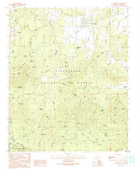 1990 Clay Springs1991 Print · USGSThe high plateau of Navajo County is documented here during the late twentieth century, showing the forest and canyon country north of the Mogollon Rim. Local historians can trace the Old Grade Railroad and locate community landmarks like the Cem and PO in Clay Springs.
 - 1998 Map of Clay Springs, 2000 Print
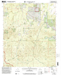 1998 Clay Springs2000 Print · USGSNavajo County's high forest country is captured here during the late nineties, centered on the community of Clay Springs. Researchers can trace early routes like the General George Crook Nat Rec Trail and locate local landmarks including the Cem and Historical Marker.
End of results
Showing maps 1-2 of 2
Top cities near Pinedale
Frequently asked questions
- What are the different types of historical maps available for Pinedale?
- What is the oldest map of Pinedale?
- Where can I purchase historical maps of Pinedale for my home or office?
- Where can I download high-res historical maps of Pinedale?
- Are there historical topographic maps available for Pinedale?
- Is there historical aerial imagery available for Pinedale?
- Where are historical maps of Pinedale sourced from?