1960s Maps of Pinetop-Lakeside, Arizona
Explore 4 historic maps of Pinetop-Lakeside from the 1960s. These maps offer a rare glimpse into what life looked like during the 1960s — showing old roads, neighborhoods, homes, and landmarks that have changed or disappeared over time.
Whether you're researching your family's past, planning a metal detecting trip, or studying how Pinetop-Lakeside's landscape evolved across the 1960s, these high-resolution maps are a powerful tool for exploring the history of this region.
- Focus on a specific era: All maps on this page are from the 1960s, giving you a focused view of this time period.
- See what’s changed: Compare century-old streets, trails, and buildings to today's modern landscape using overlays and satellite layers.
- Research with precision: Use these maps for genealogy, historical research, land use analysis, or educational projects.
- View, download, or print: Maps are fully viewable online in high resolution, and can be downloaded or printed for your own records.
Start exploring Pinetop-Lakeside's history through authentic maps from the 1960s. This is your window into the past.
Pinetop-Lakeside, AZ maps
(4)- 1960 Map of Holbrook
 1960 Holbrook1960 Print · USGSNorthern Arizona is captured here just as modern highways began to reshape the cattle and timber country of the Colorado Plateau. Genealogists and historians can trace the early footprints of Snowflake, Sedona, and Payson, alongside the Atchison Topeka & Santa Fe RR rail line.
 - 1961 Map of Show Low, 1963 Print
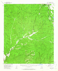 1961 Show Low1963 Print · USGSShow Low and the northern reaches of the White Mountains are captured here in the early sixties as the region's modern infrastructure began to take shape. Researchers can trace early ranching outposts like West Ranch and find local landmarks such as the Forestdale Trading Post and Show Low Lake.2 unique versions available
 - 1961 Map of McNary, 1963 Print
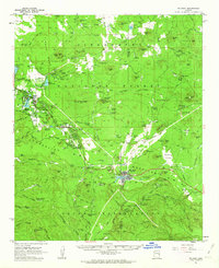 1961 McNary1963 Print · USGSThe high country of Apache and Navajo Counties comes into focus during the early sixties, showing the vital intersection of the timber industry and emerging lakeside communities. Researchers can trace family sites near Lakeside Cem, the remote Indian Pine settlement, and several Cinder Pits along the Mogollon Rim.2 unique versions available
 - 1962 Map of Saint Johns
 1962 Saint Johns1962 Print · USGSEastern Arizona and the New Mexico borderlands come alive in the early sixties, showing a landscape of high-plateau ranching and early national monuments. Trace the path of the Atchison Topeka and Santa Fe or locate old water sources like Salado Springs and Lyman Reservoir.
End of results
Showing maps 1-4 of 4
Top cities near Pinetop-Lakeside
Top neighborhoods of Pinetop-Lakeside
Frequently asked questions
- What are the different types of historical maps available for Pinetop-Lakeside?
- What is the oldest map of Pinetop-Lakeside?
- Where can I purchase historical maps of Pinetop-Lakeside for my home or office?
- Where can I download high-res historical maps of Pinetop-Lakeside?
- Are there historical topographic maps available for Pinetop-Lakeside?
- Is there historical aerial imagery available for Pinetop-Lakeside?
- Where are historical maps of Pinetop-Lakeside sourced from?