1960s Maps of Marana, Arizona
Explore 7 historic maps of Marana from the 1960s. These maps offer a rare glimpse into what life looked like during the 1960s — showing old roads, neighborhoods, homes, and landmarks that have changed or disappeared over time.
Whether you're researching your family's past, planning a metal detecting trip, or studying how Marana's landscape evolved across the 1960s, these high-resolution maps are a powerful tool for exploring the history of this region.
- Focus on a specific era: All maps on this page are from the 1960s, giving you a focused view of this time period.
- See what’s changed: Compare century-old streets, trails, and buildings to today's modern landscape using overlays and satellite layers.
- Research with precision: Use these maps for genealogy, historical research, land use analysis, or educational projects.
- View, download, or print: Maps are fully viewable online in high resolution, and can be downloaded or printed for your own records.
Start exploring Marana's history through authentic maps from the 1960s. This is your window into the past.
Marana, AZ maps
(7)- 1962 Map of Tucson
 1962 Tucson1962 Print · USGSSouthern Arizona in the early sixties showcases a landscape defined by burgeoning desert cities and massive military installations. Researchers can trace tribal settlements like Schuchk, legacy mining sites at Silver Bell Mine, and the early footprint of Davis-Monthan Air Force Base.
 - 1963 Map of Red Rock, 1965 Print
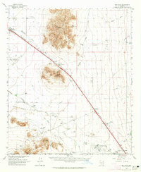 1963 Red Rock1965 Print · USGSArizona's Sonoran Desert landscape comes into focus during the early sixties, showing a corridor of growth along the railroad. Genealogists and historians can trace family-named sites like La Osa Ranch, Meeks Ranch, and the Aguirre Ranch.3 unique versions available
 - 1964 Map of Tucson
 1964 Tucson1964 Print · USGSSouthern Arizona in the mid-1960s shows a landscape of burgeoning desert cities and industrial-scale copper mining. Researchers can trace the development of Tucson and its outlying mining districts, including the Silver Bell Mine and San Manuel Mine.
 - 1967 Map of Marana, 1969 Print
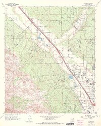
 1967 Marana1969 Print · USGSMarana and the Avra Valley are captured in the late sixties during a period of steady agricultural and rail development. Researchers can locate family landmarks such as Marana High Sch, the Marana (Siding), and the small community of Rillito along the river.4 unique versions available
 - 1968 Map of Jaynes, 1969 Print
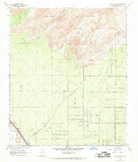
 1968 Jaynes1969 Print · USGSNorthwest of Tucson in the late sixties, the desert landscape was transitioning from a ranching economy to suburban growth. Researchers can trace the original footprints of Sahuaro Ranch, find the Yuma Mine in the foothills, or locate the Freeway Airport and Stockham along the railroad.4 unique versions available
 - 1968 Map of Ruelas Canyon, 1969 Print
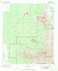
 1968 Ruelas Canyon1969 Print · USGSArizona's desert ranching culture meets the expanding road networks of Pima County in the late sixties. Genealogists and historians can trace family-named properties like Jurko Ranch and Oasis Ranch or follow the Southern Pacific railroad along the Santa Cruz River.3 unique versions available
 - 1968 Map of Avra, 1969 Print
 1968 Avra1969 Print · USGSArizona's Tucson Mountains meet the desert floor in the late sixties, showing a landscape shared by working ranches and conservation lands. Trace historical mining operations at the Gould Mine or locate early recreation sites like the Signal Hill Picnic Area.3 unique versions available
End of results
Showing maps 1-7 of 7
Top cities near Marana
- Tucson historical maps
- Oro Valley historical maps
- Picture Rocks historical maps
- South Tucson historical maps
- Avra Valley historical maps
- Red Rock historical maps
See more
Top neighborhoods of Marana
Frequently asked questions
- What are the different types of historical maps available for Marana?
- What is the oldest map of Marana?
- Where can I purchase historical maps of Marana for my home or office?
- Where can I download high-res historical maps of Marana?
- Are there historical topographic maps available for Marana?
- Is there historical aerial imagery available for Marana?
- Where are historical maps of Marana sourced from?