1980s Maps of Sahuarita, Arizona
Explore 4 historic maps of Sahuarita from the 1980s. These maps offer a rare glimpse into what life looked like during the 1980s — showing old roads, neighborhoods, homes, and landmarks that have changed or disappeared over time.
Whether you're researching your family's past, planning a metal detecting trip, or studying how Sahuarita's landscape evolved across the 1980s, these high-resolution maps are a powerful tool for exploring the history of this region.
- Focus on a specific era: All maps on this page are from the 1980s, giving you a focused view of this time period.
- See what’s changed: Compare century-old streets, trails, and buildings to today's modern landscape using overlays and satellite layers.
- Research with precision: Use these maps for genealogy, historical research, land use analysis, or educational projects.
- View, download, or print: Maps are fully viewable online in high resolution, and can be downloaded or printed for your own records.
Start exploring Sahuarita's history through authentic maps from the 1980s. This is your window into the past.
Sahuarita, AZ maps
(4)- 1981 Map of Twin Buttes
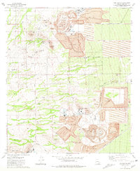 1981 Twin Buttes1981 Print · USGSArizona's copper industry was at its peak in the early 1980s, defining the landscape south of Tucson through massive open-pit operations. Researchers can trace the industrial layout of the Mission Mine and locate local landmarks like the Twin Buttes Cem and Demetrie.2 unique versions available
 - 1981 Map of Sahuarita, 1982 Print
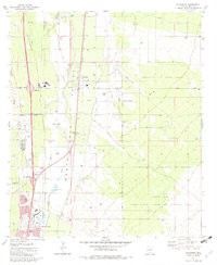 1981 Sahuarita1982 Print · USGSThe Santa Cruz Valley in the early eighties reveals a desert landscape transitioning from ranching to mining and suburban development. Genealogists and historians can trace the growth of Sahuarita and Green Valley alongside the Southern Pacific rails.2 unique versions available
 - 1981 Map of Green Valley, 1982 Print
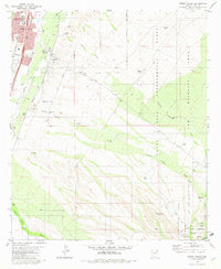 1981 Green Valley1982 Print · USGSGreen Valley and the Santa Cruz River valley are shown in the early 1980s as suburban development meets the working landscape of the Arizona desert. Genealogists and local historians can locate the Continental Sch, the Cem near the river, and the vast Santa Rita Experimental Range.
 - 1983 Map of Tucson SW
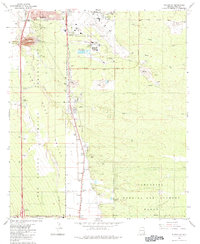 1983 Tucson SW1983 Print · USGSTucson's southern edge in the early eighties reveals a landscape of aviation, industry, and tribal lands. Researchers can trace the Southern Pacific line past Martinez Hill or locate the sprawling Sahuarita Bombing and Gunnery Range.
End of results
Showing maps 1-4 of 4
Top cities near Sahuarita
Top neighborhoods of Sahuarita
Frequently asked questions
- What are the different types of historical maps available for Sahuarita?
- What is the oldest map of Sahuarita?
- Where can I purchase historical maps of Sahuarita for my home or office?
- Where can I download high-res historical maps of Sahuarita?
- Are there historical topographic maps available for Sahuarita?
- Is there historical aerial imagery available for Sahuarita?
- Where are historical maps of Sahuarita sourced from?