1900-1909 Maps of Sahuarita, Arizona
Explore 4 historic maps of Sahuarita from 1900-1909. These maps offer a rare glimpse into what life looked like during the 1900s — showing old roads, neighborhoods, homes, and landmarks that have changed or disappeared over time.
Whether you're researching your family's past, planning a metal detecting trip, or studying how Sahuarita's landscape evolved across the 1900s, these high-resolution maps are a powerful tool for exploring the history of this region.
- Focus on a specific era: All maps on this page are from the 1900s, giving you a focused view of this time period.
- See what’s changed: Compare century-old streets, trails, and buildings to today's modern landscape using overlays and satellite layers.
- Research with precision: Use these maps for genealogy, historical research, land use analysis, or educational projects.
- View, download, or print: Maps are fully viewable online in high resolution, and can be downloaded or printed for your own records.
Start exploring Sahuarita's history through authentic maps from the 1900s. This is your window into the past.
Sahuarita, AZ maps
(4)- 1904 Map of Patagonia, 1955 Print
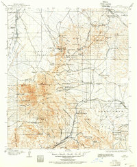 1904 Patagonia1955 Print · USGSArizona's mining and ranching frontiers are at their peak in this early century survey of the Santa Rita Mountains. Genealogists and historians can trace family operations at the Empire Ranch or the Total Wreck Mine, and locate the site of Old Ft Crittenden.
 - 1904 Map of Tucson, 1957 Print
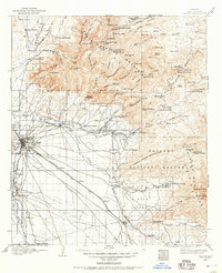 1904 Tucson1957 Print · USGSTucson and its surrounding desert basins are captured here at the turn of the century as the railroad transformed this Pima County landscape. Genealogists and historians can locate early family holdings like Carrillos Ranch, the site of Old Fort Lowell, and the remote Loma Verde Mines.
 - 1905 Map of Patagonia
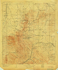 1905 Patagonia1905 Print · USGSSouthern Arizona’s mining and ranching frontier is captured here at the start of the twentieth century. Genealogists and historians can trace numerous family homesteads and active mining sites, from Empire Ranch and Helvetia to the curiously named Total Wreck Mine.4 unique versions available
 - 1905 Map of Tucson
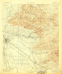 1905 Tucson1905 Print · USGSEarly 1900s Tucson is shown here as a railway hub at the base of the Rincon and Santa Catalina mountains. Genealogists and historians can trace numerous family homesteads like Pusch's Ranch, explore Old Fort Lowell, or locate the Loma Verde Mines.5 unique versions available
End of results
Showing maps 1-4 of 4
Top cities near Sahuarita
Top neighborhoods of Sahuarita
Frequently asked questions
- What are the different types of historical maps available for Sahuarita?
- What is the oldest map of Sahuarita?
- Where can I purchase historical maps of Sahuarita for my home or office?
- Where can I download high-res historical maps of Sahuarita?
- Are there historical topographic maps available for Sahuarita?
- Is there historical aerial imagery available for Sahuarita?
- Where are historical maps of Sahuarita sourced from?