1900s (20th Century) Maps of Trench Camp, Arizona
Explore 11 historic maps of Trench Camp from the 1900s (20th Century). These maps offer a rare glimpse into what life looked like during the 1900s — showing old roads, neighborhoods, homes, and landmarks that have changed or disappeared over time.
Whether you're researching your family's past, planning a metal detecting trip, or studying how Trench Camp's landscape evolved across the 1900s, these high-resolution maps are a powerful tool for exploring the history of this region.
- Focus on a specific era: All maps on this page are from the 1900s, giving you a focused view of this time period.
- See what’s changed: Compare century-old streets, trails, and buildings to today's modern landscape using overlays and satellite layers.
- Research with precision: Use these maps for genealogy, historical research, land use analysis, or educational projects.
- View, download, or print: Maps are fully viewable online in high resolution, and can be downloaded or printed for your own records.
Start exploring Trench Camp's history through authentic maps from the 1900s. This is your window into the past.
Trench Camp, AZ maps
(11)- 1905 Map of Nogales
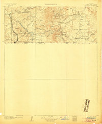 1905 Nogales1905 Print · USGSThe Arizona-Mexico borderlands are captured here at the height of the mining boom and the expansion of the Southern Pacific RR. Genealogists and historians can trace family landholdings from Calabasas to Lochiel or locate remote sites like The Mowry Mine and Fuller's Ranch.4 unique versions available
 - 1932 Map of Lochiel
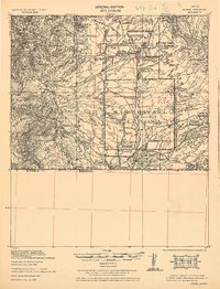 1932 Lochiel1932 Print · USGSThe Arizona-Mexico borderlands come alive in this early 1930s survey of the high desert and San Rafael Valley. Researchers can trace family ranching legacies at Stevensons Ranch or explore the mining history of The Mowry Mine and Harshaw.2 unique versions available
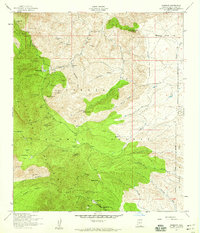
 - 1948 Map of Harshaw, 1953 Print
 1948 Harshaw1953 Print · USGSArizona's copper and silver mining legacy is etched across the Patagonia Mountains in the late 1940s. Genealogists and historians can trace old claims like the Hardshell Mine and Paymaster Mine or locate the site of Washington Camp and the Duquesne Sch.
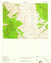
 - 1948 Map of Lochiel, 1958 Print
 1948 Lochiel1958 Print · USGSThe Arizona-Mexico borderlands in the late 1940s reveal a landscape of remote mining camps and sprawling cattle ranches. Researchers can trace the legacy of early mining at Washington Camp and Duquesne, or locate the Custom House at the international crossing in Lochiel.
 - 1956 Map of Nogales, 1963 Print
 1956 Nogales1963 Print · USGSSouthern Arizona in the mid-fifties is captured here from the Papago tribal lands to the San Pedro valley. Genealogists and historians can trace border settlements like Sasabe, the legacy of Tombstone, and old mining sites including the Mary G Mine.4 unique versions available
 - 1958 Map of Nogales
 1958 Nogales1958 Print · USGSSouthern Arizona in the late fifties was a landscape of international borders and high-desert outposts, dominated by the Huachuca Mountains and the Papago Indian Reservation. Local historians can trace old mining camps like Ruby and Greaterville or locate historic military grounds at the Fort Huachuca Military Reservation.
 - 1958 Map of Harshaw, 1959 Print
 1958 Harshaw1959 Print · USGSThe Patagonia Mountains are mapped here during the late fifties, showcasing a high-desert landscape still defined by its mineral wealth and ranching roots. Genealogists and metal detectorists can trace the roads between Harshaw, Washington Camp, and dozens of historic workings like the Mowry Mine and Hardshell Mine.3 unique versions available
 - 1958 Map of Lochiel, 1959 Print
 1958 Lochiel1959 Print · USGSSouthern Arizona’s mining and ranching frontier is captured here during the mid-century, stretching from the Patagonia Mountains to the San Rafael Valley. Researchers can locate dozens of individual mine shafts and settlements like Duquesne, Washington Camp, and the border outpost of Lochiel.2 unique versions available
 - 1959 Map of Nogales
 1959 Nogales1959 Print · USGSThe Southern Arizona borderlands appear in the late fifties as a complex landscape of military ranges, tribal lands, and high-desert mining towns. Local historians can trace the Southern Pacific rail lines connecting Tombstone and Benson or locate family ranches such as Canoa Ranch.
 - 1994 Map of Nogales
 1994 Nogales1994 Print · USGSThe Arizona-Sonora borderlands come into focus in the mid-1990s, showcasing the intricate Spanish land grants and mining districts that shaped the region. Genealogists and historians can trace old mining camps like Washington Camp and Duquesne or locate the historic Mowry Mine.2 unique versions available
 - 1996 Map of Harshaw, 2003 Print
 1996 Harshaw2003 Print · USGSThe Patagonia Mountains come alive in the late twentieth century with this detailed view of Arizona's deep mining and ranching history. Trace the remnants of old silver works like the Mowry Mine or locate early settlements at Harshaw and Washington Camp.
End of results
Showing maps 1-11 of 11
Top cities near Trench Camp
- Nogales historical maps
- Town of Patagonia historical maps
- Patagonia historical maps
- Sonoita historical maps
Frequently asked questions
- What are the different types of historical maps available for Trench Camp?
- What is the oldest map of Trench Camp?
- Where can I purchase historical maps of Trench Camp for my home or office?
- Where can I download high-res historical maps of Trench Camp?
- Are there historical topographic maps available for Trench Camp?
- Is there historical aerial imagery available for Trench Camp?
- Where are historical maps of Trench Camp sourced from?