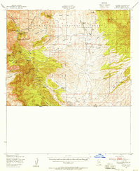
1948 Map of Lochiel
USGS Topo · Published 1958About this map
Mining operations and cattle ranching define this high-desert landscape along the international border in the late 1940s. The Patagonia Mountains dominate the western terrain, where a cluster of historic workings including the Worlds Fair Mine, Humboldt Mine, and Morning Glory Mine speak to the region's mineral wealth. Nearby, the settlements of Harshaw, Washington Camp, and Duquesne serve as focal points for local commerce and education, the latter featuring the Duquesne Sch.
Find a feature on this map
58 named features on this map. Tap any name to fly to it.
Don’t see what you’re looking for? This feature index may not catch every label — zoom into the map to look around manually.
Map Details
Editions of this 1948 Lochiel Map
This is the sole edition of this map. No revisions or reprints were ever made.
Other maps of this area

1904 · Patagonia
USGS Topo · 1:125,000

1905 · Patagonia
USGS Topo · 1:125,000

1905 · Nogales
USGS Topo · 1:125,000

1914 · Hereford
USGS Topo · 1:125,000

1915 · Benson
USGS Topo · 1:125,000

1922 · Agus Caliente
USGS Topo · 1:62,500

1922 · Sunnyside
USGS Topo · 1:62,500

1932 · Lochiel
USGS Topo · 1:62,500

1932 · Elgin
USGS Topo · 1:62,500

1933 · Calabasas
USGS Topo · 1:62,500