1980s Maps of Yuma, Arizona
Explore 2 historic maps of Yuma from the 1980s. These maps offer a rare glimpse into what life looked like during the 1980s — showing old roads, neighborhoods, homes, and landmarks that have changed or disappeared over time.
Whether you're researching your family's past, planning a metal detecting trip, or studying how Yuma's landscape evolved across the 1980s, these high-resolution maps are a powerful tool for exploring the history of this region.
- Focus on a specific era: All maps on this page are from the 1980s, giving you a focused view of this time period.
- See what’s changed: Compare century-old streets, trails, and buildings to today's modern landscape using overlays and satellite layers.
- Research with precision: Use these maps for genealogy, historical research, land use analysis, or educational projects.
- View, download, or print: Maps are fully viewable online in high resolution, and can be downloaded or printed for your own records.
Start exploring Yuma's history through authentic maps from the 1980s. This is your window into the past.
Yuma, AZ maps
(2)- 1980 Map of Tinajas Altas Mts
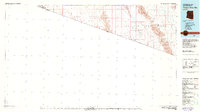 1980 Tinajas Altas Mts1980 Print · USGSThe Arizona-Sonora borderlands come into focus in the early eighties, showing a landscape shaped by military use and extreme desert terrain. Researchers can trace the Jeep Trail through the Tinajas Altas Mountains or locate the Smith Mine and San Luis Landing Field.2 unique versions available
 - 1982 Map of Tinajas Altas
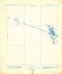 1982 Tinajas Altas1982 Print · USGSThe Arizona-Sonora borderlands come into focus in this military survey, which tracks the international line across the southern Yuma Desert. Researchers can locate historic boundary markers like Mon. 197 and water catchments at Tinajas Altas.
End of results
Showing maps 1-2 of 2
Top cities near Yuma
- Fortuna Foothills historical maps
- San Luis historical maps
- Somerton historical maps
- Avenue B & C historical maps
- Donovan Estates historical maps
- Gadsden historical maps
See more
Top neighborhoods of Yuma
- Araby historical maps
- Hacienda Estates historical maps
- Rancho Caballo historical maps
- Kofa Acres historical maps
- Desert View historical maps
- Hansberger historical maps
See more
Frequently asked questions
- What are the different types of historical maps available for Yuma?
- What is the oldest map of Yuma?
- Where can I purchase historical maps of Yuma for my home or office?
- Where can I download high-res historical maps of Yuma?
- Are there historical topographic maps available for Yuma?
- Is there historical aerial imagery available for Yuma?
- Where are historical maps of Yuma sourced from?