1970s Maps of Bradley County, Arkansas
Explore 15 historic maps of Bradley County from the 1970s. These maps offer a rare glimpse into what life looked like during the 1970s — showing old roads, neighborhoods, homes, and landmarks that have changed or disappeared over time.
Whether you're researching your family's past, planning a metal detecting trip, or studying how Bradley County's landscape evolved across the 1970s, these high-resolution maps are a powerful tool for exploring the history of this region.
- Focus on a specific era: All maps on this page are from the 1970s, giving you a focused view of this time period.
- See what’s changed: Compare century-old streets, trails, and buildings to today's modern landscape using overlays and satellite layers.
- Research with precision: Use these maps for genealogy, historical research, land use analysis, or educational projects.
- View, download, or print: Maps are fully viewable online in high resolution, and can be downloaded or printed for your own records.
Start exploring Bradley County's history through authentic maps from the 1970s. This is your window into the past.
Bradley County, AR maps
(15)- 1971 Map of Vick, 1973 Print
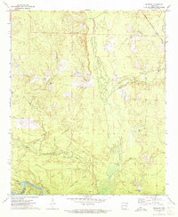
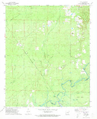 1971 Vick1973 Print · USGSBradley County during the early seventies is mapped here along the winding banks of the Saline River. Genealogists and historians can trace the rail-and-river landscape through the Chicago Rock Island and Pacific tracks, Hampton Chapel, and the settlement at Vick.3 unique versions available
 - 1971 Map of Hermitage, 1973 Print
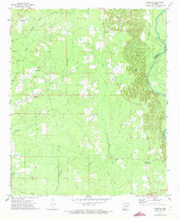
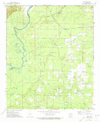
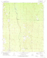
 1971 Hermitage1973 Print · USGSHermitage and the surrounding Bradley County timberlands are captured here in the early 1970s as the regional rail economy remained vital. Researchers can locate family landmarks like Holly Springs Cem, the community of Ingalls, and the winding L'Aigle Creek bottoms.2 unique versions available
 - 1971 Map of Sumpter, 1973 Print
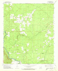
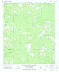
 1971 Sumpter1973 Print · USGSThe rural backroads of Bradley and Drew counties come into focus in the early 1970s as the river bottom timberlands meet rising gravel hills. Trace the vanished tracks of the Old Railroad Grade or locate family roots near Pattsville Cem and Sumpter.2 unique versions available
 - 1971 Map of Longview, 1973 Print
 1971 Longview1973 Print · USGSIn the early seventies, the Saline River bottomlands of southeast Arkansas remained a landscape of quiet river crossings and family-named landmarks. Genealogists can trace rural community centers like Longview, Bethel Ch, and the Prairie Chapel Cem.
 - 1971 Map of Marsden, 1973 Print
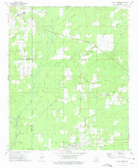
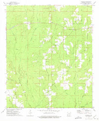
 1971 Marsden1973 Print · USGSIn the early 1970s, this portion of Bradley County was a landscape of timbered ridges and river bottomlands. Genealogists and local historians can trace family locations near Marsden, Crossroads Ch, and the Cem Wearied Rest Ch.2 unique versions available
 - 1971 Map of Milo, 1973 Print
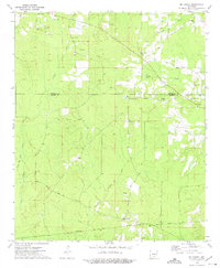
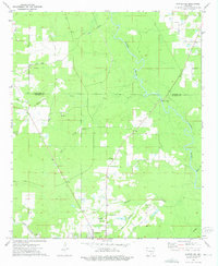
 1971 Milo1973 Print · USGSSoutheast Arkansas in the early seventies shows a landscape defined by the winding Saline River and a dense network of country churches. Researchers can trace family roots at Old Milo, Egypt Ch, or Duckworth Cem and locate historic river points like Moffatt Bluff.
 - 1972 Map of Wilmar South, 1975 Print
 1972 Wilmar South1975 Print · USGSSoutheast Arkansas in the early seventies remains a landscape of small river settlements and rural congregations. Genealogists and local historians can trace family locations through numerous sites like Turner Hills Cem, New Hope, and the Shiloh Ch area.
 - 1973 Map of Wilmar North, 1975 Print
 1973 Wilmar North1975 Print · USGSThe rural timberlands of Drew and Bradley Counties are captured here in the early seventies, centered on the Saline River and its many tributaries. Genealogists can trace family roots through sites like Bethel Cemetery, Union Church, and the settlement of Barkada.
 - 1973 Map of Warren, 1975 Print
 1973 Warren1975 Print · USGSWarren was a bustling Bradley County rail and timber center in the early seventies, caught here just as the river-and-rail economy transitioned. Genealogists and local historians can trace family roots through sites like Oakland Cemetery, St James Church, and the outlying settlement of Carmel.2 unique versions available
 - 1973 Map of Mc Kinney, 1975 Print
 1973 Mc Kinney1975 Print · USGSThe borderlands of Bradley and Cleveland County appear here in the early seventies, caught between a history of timber rail and rural settlement. Researchers can locate numerous family burial sites like Reeves Cem or trace the path of the Old Railroad Grade near Mc Kinney.2 unique versions available
 - 1973 Map of Farmville, 1975 Print
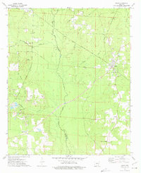
 1973 Farmville1975 Print · USGSBradley County in the early seventies remained a landscape of timber, creeks, and quiet rural crossroads. Researchers can trace family sites at Craney Cem, follow the Chicago Rock Island and Pacific line, or locate the old Banks Lookout Tower.2 unique versions available
 - 1973 Map of Tinsman, 1975 Print
 1973 Tinsman1975 Print · USGSThe timberlands and creek bottoms of southern Arkansas come alive in this early 1970s survey of the tri-county borderlands. Researchers can trace the Chicago Rock Island and Pacific rail line and locate landmarks like Williams Cem and the Old Camden Road.2 unique versions available
 - 1973 Map of Warren NE, 1975 Print
 1973 Warren NE1975 Print · USGSThe Bradley County timberlands and the outskirts of Warren are captured here in the mid-seventies. Researchers can trace rural life through numerous landmarks like Macedonia Ch, Seay Cem, and the historic Old Camden Road.2 unique versions available
 - 1973 Map of Banks, 1975 Print
 1973 Banks1975 Print · USGSSouth-central Arkansas appears here during the early seventies, centered on the railroad town of Banks at the county line. Researchers can trace rural lineages through family landmarks like McFarland Cemetery and country churches such as Pleasant Grove Church.2 unique versions available
 - 1978 Map of Warren
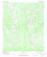
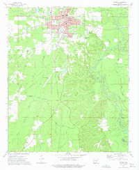
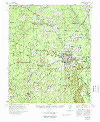 1978 Warren1978 Print · USGSBradley County life in the late 1970s centered on the hub of Warren and its network of rural churches and family farms. Researchers can trace local lineage through sites like Parnell Cem, Moseley Chapel, and the community of Farmville.
End of results
Showing maps 1-15 of 15
Top cities of Bradley County
Frequently asked questions
- What are the different types of historical maps available for Bradley County?
- What is the oldest map of Bradley County?
- Where can I purchase historical maps of Bradley County for my home or office?
- Where can I download high-res historical maps of Bradley County?
- Are there historical topographic maps available for Bradley County?
- Is there historical aerial imagery available for Bradley County?
- Where are historical maps of Bradley County sourced from?