1980s Maps of Bradley County, Arkansas
Explore 11 historic maps of Bradley County from the 1980s. These maps offer a rare glimpse into what life looked like during the 1980s — showing old roads, neighborhoods, homes, and landmarks that have changed or disappeared over time.
Whether you're researching your family's past, planning a metal detecting trip, or studying how Bradley County's landscape evolved across the 1980s, these high-resolution maps are a powerful tool for exploring the history of this region.
- Focus on a specific era: All maps on this page are from the 1980s, giving you a focused view of this time period.
- See what’s changed: Compare century-old streets, trails, and buildings to today's modern landscape using overlays and satellite layers.
- Research with precision: Use these maps for genealogy, historical research, land use analysis, or educational projects.
- View, download, or print: Maps are fully viewable online in high resolution, and can be downloaded or printed for your own records.
Start exploring Bradley County's history through authentic maps from the 1980s. This is your window into the past.
Bradley County, AR maps
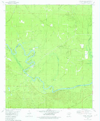
(11)- 1981 Map of New Union
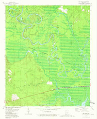 1981 New Union1981 Print · USGSThe river bottomlands of southern Arkansas are captured here in the early eighties, showcasing the intersection of the Ouachita River and Saline River. Genealogists and researchers can trace the vicinity of New Union or locate specific river landmarks like Prairie Island Landing and Fishtrap Lake.2 unique versions available
 - 1981 Map of Marais Saline
 1981 Marais Saline1981 Print · USGSLower Arkansas river country is captured here in the early eighties as the Felsenthal wetlands meet industrial lake development. Genealogists and local historians can trace family-named routes like J D Pippen Road or locate the Arkadelphia Cem and Godfrey Landing.
 - 1981 Map of Artesian
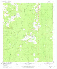
 1981 Artesian1981 Print · USGSCalhoun County in the late seventies and early eighties shows a rural landscape shaped by timber and petroleum. Researchers can locate family landmarks like Friendship Cem, study the Artesian Oil Field, or trace the winding course of Little Champagnolle Creek.
 - 1981 Map of Jersey
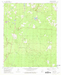
 1981 Jersey1981 Print · USGSIn the early 1980s, this portion of the Calhoun and Bradley county line was a network of rural creek branches and crossroads congregations. Family historians can locate several burial sites and churches including Hienes Cem, Belin Cem, and Mt Zion Ch.
 - 1981 Map of Harrell Brake
 1981 Harrell Brake1981 Print · USGSThe riverfront of the late 1970s is preserved here as the Ouachita River snakes through the bottomlands of Calhoun and Union counties. Genealogists and researchers can trace the locations of Bangs Landing, Wilmington Landing, and the settlement of Lawson.
 - 1981 Map of Moro Bay
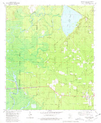
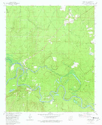 1981 Moro Bay1981 Print · USGSIn the river bottoms of southern Arkansas during the early eighties, the landscape was a mix of quiet wetlands and active oil production. Genealogists and historians can trace family locations near the Hilo Cem, explore the early footprint of Moro Bay State Park, and locate the historic Careyville Landing river access.
 - 1985 Map of El Dorado, 1986 Print
 1985 El Dorado1986 Print · USGSSouth-central Arkansas and the Louisiana borderlands appear here in the mid-1980s, defined by the energy industry and river bottomlands. Genealogists and historians can locate rural landmarks like Old Parkers Chapel Cem, the Smackover Gas Field, and the El Dorado & Wesson RR.2 unique versions available
 - 1986 Map of Dumas
 1986 Dumas1986 Print · USGSSoutheast Arkansas in the mid-eighties shows a landscape defined by the winding Mississippi River and the Missouri Pacific Railroad corridor. Genealogists can trace family roots through river towns like Arkansas City and the rail-junction history of McGehee.2 unique versions available
 - 1986 Map of Camden
 1986 Camden1986 Print · USGSSouth Arkansas in the 1980s remains a landscape shaped by river valleys and the legacy of the timber industry. Researchers can trace the massive Abandoned Ammunition Depot or locate family roots in Eagle Mills, Bearden, and Tinsman.
 - 1986 Map of Crossett
 1986 Crossett1986 Print · USGSSoutheast Arkansas and the Mississippi Delta meet in the mid-1980s, revealing a landscape of rail-linked towns and river bottomlands. Researchers can trace the Missouri Pacific line through Hamburg and Parkdale or locate Millers Chapel and Winterville Mounds State Park.2 unique versions available
 - 1989 Map of El Dorado, 1990 Print
 1989 El Dorado1990 Print · USGSThe Arkansas-Louisiana borderlands in the late eighties show a landscape of heavy industry and wildlife conservation centered on the Ouachita River. Researchers can trace the legacy of timber and transport via the Missouri Pacific RR, Poison Springs State Forest, and the vast Felsenthal Pool.
End of results
Showing maps 1-11 of 11
Top cities of Bradley County
Frequently asked questions
- What are the different types of historical maps available for Bradley County?
- What is the oldest map of Bradley County?
- Where can I purchase historical maps of Bradley County for my home or office?
- Where can I download high-res historical maps of Bradley County?
- Are there historical topographic maps available for Bradley County?
- Is there historical aerial imagery available for Bradley County?
- Where are historical maps of Bradley County sourced from?