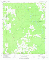
1973 Map of Warren NE
USGS Topo · Published 1975About this map
Warren serves as the primary hub at the southern edge of this survey, where the town's industrial footprint is marked by the Radio Tower (KWRF) and a sprawling network of local roads. The landscape transitions from the developed streets of the city into the timber-heavy terrain of the Cleveland Co Bradley Co border. This area is defined by the winding course of the Saline River and its numerous tributaries, including Hollis Creek and Seay Creek, which drain the low-lying bottomlands.
Find a feature on this map
29 named features on this map. Tap any name to fly to it.
Don’t see what you’re looking for? This feature index may not catch every label — zoom into the map to look around manually.
Map Details
Editions of this 1973 Warren NE Map
2 editions found
Other maps of this area

1935 · Feenyville
USGS Topo · 1:62,500

1953 · Greenwood
USGS Topo · 1:250,000

1953 · El Dorado
USGS Topo · 1:250,000

1956 · Greenwood
USGS Topo · 1:250,000

1957 · El Dorado
USGS Topo · 1:250,000

1958 · El Dorado
USGS Topo · 1:250,000

1960 · El Dorado
USGS Topo · 1:250,000

1970 · New Edinburg
USGS Topo · 1:24,000

1970 · Herbine
USGS Topo · 1:24,000
1972 · Wilmar South
USGS Topo · 1:24,000