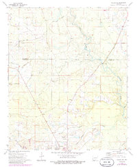
1973 Map of Warren NE
USGS Topo · Published 1986About this map
The Saline River winds through the eastern portion of this Arkansas landscape, defining the topography south of the Cleveland Co / Bradley Co line. In the south, the northern reaches of Warren are visible, featuring the Radio Tower (KWRF) and the Union Cem. The area is characterized by a high density of rural religious and burial sites, including Emmaus Ch and Beard Cem, which serve the small communities scattered along the upland ridges. Historical transport routes like Cow Ford Road and Old Camden Road cross the terrain, linking isolated farmsteads to the larger settlement. The 1984 photorevisions on this 1973 survey highlight changes in land use and vegetation, particularly near Town Branch and Franklin Branch, offering a distinct look at the transition from wild bottomlands to managed timber and agriculture.
Find a feature on this map
29 named features on this map. Tap any name to fly to it.
Don’t see what you’re looking for? This feature index may not catch every label — zoom into the map to look around manually.
Map Details
Editions of this 1973 Warren NE Map
2 editions found
Other maps of this area

1935 · Feenyville
USGS Topo · 1:62,500

1953 · Greenwood
USGS Topo · 1:250,000

1953 · El Dorado
USGS Topo · 1:250,000

1956 · Greenwood
USGS Topo · 1:250,000

1957 · El Dorado
USGS Topo · 1:250,000

1958 · El Dorado
USGS Topo · 1:250,000

1960 · El Dorado
USGS Topo · 1:250,000

1970 · New Edinburg
USGS Topo · 1:24,000

1970 · Herbine
USGS Topo · 1:24,000
1972 · Wilmar South
USGS Topo · 1:24,000