1957 Map of El Dorado
USGS Topo · Published 1957About this map
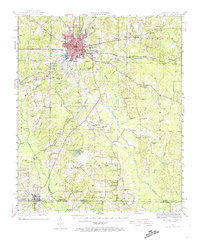
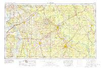
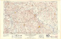
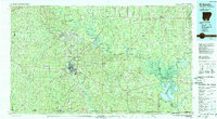
The U.S. Naval Ammunition Depot stands as a massive installations north of El Dorado, anchoring a landscape defined by the heavy industrial and logistical networks of south Arkansas in the mid-1950s. This survey captures the region's complex water system, where the Ouachita River and Red River frame a network of drainage including Dorcheat Bayou and Smackover Creek. The area is a hub of postwar transportation, shown through the convergence of major rail lines like the Missouri Pacific Railroad and the St. Louis Southwestern Railway which connected timber and oil centers like Magnolia, Camden, and Stamps.
Find a feature on this map
79 named features on this map. Tap any name to fly to it.
Don’t see what you’re looking for? This feature index may not catch every label — zoom into the map to look around manually.
Map Details
Editions of this 1957 El Dorado Map
This is the sole edition of this map. No revisions or reprints were ever made.
Historical Maps of Texarkana Through Time
9 maps found