1960s Maps of Clark County, Arkansas
Explore 8 historic maps of Clark County from the 1960s. These maps offer a rare glimpse into what life looked like during the 1960s — showing old roads, neighborhoods, homes, and landmarks that have changed or disappeared over time.
Whether you're researching your family's past, planning a metal detecting trip, or studying how Clark County's landscape evolved across the 1960s, these high-resolution maps are a powerful tool for exploring the history of this region.
- Focus on a specific era: All maps on this page are from the 1960s, giving you a focused view of this time period.
- See what’s changed: Compare century-old streets, trails, and buildings to today's modern landscape using overlays and satellite layers.
- Research with precision: Use these maps for genealogy, historical research, land use analysis, or educational projects.
- View, download, or print: Maps are fully viewable online in high resolution, and can be downloaded or printed for your own records.
Start exploring Clark County's history through authentic maps from the 1960s. This is your window into the past.
Clark County, AR maps
(8)- 1960 Map of El Dorado
 1960 El Dorado1960 Print · USGSSouth Central Arkansas in the late fifties was a hub of energy production and defense industry. Researchers can trace the extensive Oil and Gas Fields around El Dorado or locate family landmarks like Old Park Cem and New Hope Church.
 - 1960 Map of Little Rock
 1960 Little Rock1960 Print · USGSCentral Arkansas in the late fifties shows a landscape of growing military bases and massive new reservoirs. Local historians can trace the mid-century expansion of Little Rock and Hot Springs alongside the industrial works at Bauxite and the Pine Bluff Arsenal.
 - 1964 Map of Little Rock
 1964 Little Rock1964 Print · USGSCentral Arkansas in the mid-sixties is a landscape of mountain ridges, industrial rail lines, and growing military hubs. Researchers can trace the development of Bauxite and Hot Springs or locate rural landmarks like Sparkman and the Pine Bluff Arsenal.
 - 1964 Map of Donaldson, 1965 Print
 1964 Donaldson1965 Print · USGSHot Spring County’s river-and-rail landscape is captured here in the mid-sixties, centered on the activity of Donaldson and Friendship. Genealogists and local historians can trace rural roots through the locations of Mt Pleasant Cem, Riverside Ch, and the Ouachita High Sch.3 unique versions available
 - 1965 Map of Dalark, 1966 Print
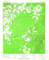
 1965 Dalark1966 Print · USGSMid-century Clark County comes alive in this survey of the riverlands and rural townships. Genealogists and historians can trace family roots at Strong Cem and Jones Cem, or follow the path of the Old Railroad Grade near Griffithtown.
 - 1966 Map of Point Cedar, 1967 Print
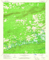 1966 Point Cedar1967 Print · USGSNear the Clark and Hot Spring county line in the mid-sixties, the river valley was undergoing a major transformation. Researchers can trace the original path of the Caddo River and locate rural landmarks like Wesleyan Chapel, Runyan Bridge, and Point Cedar.2 unique versions available
 - 1966 Map of Bismarck, 1967 Print
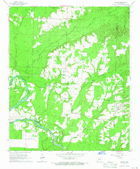
 1966 Bismarck1967 Print · USGSBismarck and the Caddo River valley are caught in a moment of transition during the mid-sixties as the local landscape prepares for the rising waters of the De Gray Reservoir. Genealogists and local historians can trace rural roots through several country churches like Pleasant Hill Ch and the De Roche Cem.2 unique versions available
 - 1966 Map of Amity, 1967 Print
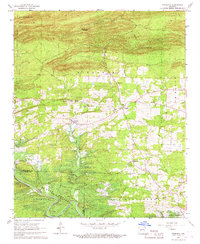
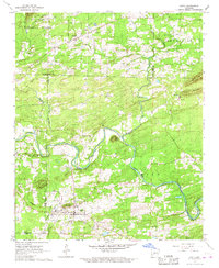 1966 Amity1967 Print · USGSAmity and the Caddo River valley are documented here in the mid-1960s, a period of transition for the rural landscapes of Clark and Montgomery counties. Family historians can trace the locations of Old Mt Tabor Ch, the Dillard Cem, and the path of the Missouri Pacific railroad.
End of results
Showing maps 1-8 of 8
Top cities of Clark County
- Arkadelphia historical maps
- Gurdon historical maps
- Amity historical maps
- Caddo Valley historical maps
- Gum Springs historical maps
- Okolona historical maps
See more
Frequently asked questions
- What are the different types of historical maps available for Clark County?
- What is the oldest map of Clark County?
- Where can I purchase historical maps of Clark County for my home or office?
- Where can I download high-res historical maps of Clark County?
- Are there historical topographic maps available for Clark County?
- Is there historical aerial imagery available for Clark County?
- Where are historical maps of Clark County sourced from?