1980s Maps of Cleburne County, Arkansas
Explore 7 historic maps of Cleburne County from the 1980s. These maps offer a rare glimpse into what life looked like during the 1980s — showing old roads, neighborhoods, homes, and landmarks that have changed or disappeared over time.
Whether you're researching your family's past, planning a metal detecting trip, or studying how Cleburne County's landscape evolved across the 1980s, these high-resolution maps are a powerful tool for exploring the history of this region.
- Focus on a specific era: All maps on this page are from the 1980s, giving you a focused view of this time period.
- See what’s changed: Compare century-old streets, trails, and buildings to today's modern landscape using overlays and satellite layers.
- Research with precision: Use these maps for genealogy, historical research, land use analysis, or educational projects.
- View, download, or print: Maps are fully viewable online in high resolution, and can be downloaded or printed for your own records.
Start exploring Cleburne County's history through authentic maps from the 1980s. This is your window into the past.
Cleburne County, AR maps
(7)- 1983 Map of Mountain View
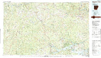 1983 Mountain View1983 Print · USGSNorth-central Arkansas comes into sharp focus during the early eighties, showing the transition from traditional Ozark mountain settlements to a landscape shaped by major reservoirs. Genealogists and historians can trace family roots through mountain hamlets like Snowball, Witts Springs, and Timbo, or locate landmarks such as Zion Hill Church and the Missouri Pacific Railroad.
 - 1983 Map of Conway, 1984 Print
 1983 Conway1984 Print · USGSThe Arkansas River valley in the early eighties shows a landscape of river-bend settlements and expanding wildlife areas. Genealogists and historians can trace the Missouri Pacific RR through old river towns like Toad Suck, Morrilton, and Menifee.
 - 1984 Map of Russellville
 1984 Russellville1984 Print · USGSThe Arkansas River valley was undergoing significant change in the 1950s as transportation and water management reshaped the region from Russellville to Conway. Researchers can trace the era's rail networks like the Missouri Pacific RR and explore landmarks like Magazine Mountain and Petit Jean State Park.
 - 1986 Map of Searcy
 1986 Searcy1986 Print · USGSWhite County and its neighbors reached a period of established agricultural and rail prosperity by the mid-1980s. Local researchers can trace the routes of the Missouri Pacific RR and locate rural communities like Velvet Ridge, Sunnydale, and Cotton Plant.2 unique versions available
 - 1986 Map of Batesville
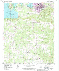
 1986 Batesville1986 Print · USGSNorth-central Arkansas in the mid-eighties shows a landscape of river-bend towns and Ozark foothills during a period of steady growth. You can trace family roots through numerous upland sites like Hickory Valley School, Sandtown Hill Cem, and the riverfront at Oil Trough.2 unique versions available
 - 1989 Map of Heber Springs, 1995 Print
 1989 Heber Springs1995 Print · USGSHeber Springs and the southern reaches of the Ozark foothills are documented here in the late twentieth century. Researchers can trace rural lineages through numerous country churches like Friendship Ch and historic burial grounds such as Palestine Cem.
 - 1989 Map of Morganton, 1995 Print
 1989 Morganton1995 Print · USGSVan Buren and Cleburne counties appear here in the late eighties, just as the rural landscape of the North Fork Cadron Creek was being updated. Researchers can trace family roots through sites like Salem Ch, Gravesville, and the historic Indian Treaty Boundary.
End of results
Showing maps 1-7 of 7
Top cities of Cleburne County
- Heber Springs historical maps
- Greers Ferry historical maps
- Quitman historical maps
- Concord historical maps
- Higden historical maps
Frequently asked questions
- What are the different types of historical maps available for Cleburne County?
- What is the oldest map of Cleburne County?
- Where can I purchase historical maps of Cleburne County for my home or office?
- Where can I download high-res historical maps of Cleburne County?
- Are there historical topographic maps available for Cleburne County?
- Is there historical aerial imagery available for Cleburne County?
- Where are historical maps of Cleburne County sourced from?