1990s Maps of Cleburne County, Arkansas
Explore 6 historic maps of Cleburne County from the 1990s. These maps offer a rare glimpse into what life looked like during the 1990s — showing old roads, neighborhoods, homes, and landmarks that have changed or disappeared over time.
Whether you're researching your family's past, planning a metal detecting trip, or studying how Cleburne County's landscape evolved across the 1990s, these high-resolution maps are a powerful tool for exploring the history of this region.
- Focus on a specific era: All maps on this page are from the 1990s, giving you a focused view of this time period.
- See what’s changed: Compare century-old streets, trails, and buildings to today's modern landscape using overlays and satellite layers.
- Research with precision: Use these maps for genealogy, historical research, land use analysis, or educational projects.
- View, download, or print: Maps are fully viewable online in high resolution, and can be downloaded or printed for your own records.
Start exploring Cleburne County's history through authentic maps from the 1990s. This is your window into the past.
Cleburne County, AR maps
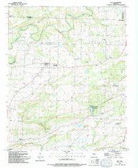
(6)- 1991 Map of Quitman, 1995 Print
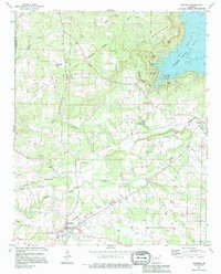 1991 Quitman1995 Print · USGSQuitman and the surrounding Cleburne County hills are shown during a period of transition as rural homesteads met the growing recreation of the lake. Researchers can locate family landmarks like Aldridge Cem, Wesley Chapel, and the historic site of Goff Ferry.
 - 1992 Map of Russellville, 1993 Print
 1992 Russellville1993 Print · USGSCentral Arkansas in the early nineties shows a landscape defined by the Arkansas River valley and the surrounding national forests. Trace the development of river towns like Russellville and Dardanelle alongside landmarks such as Lake Dardanelle and Magazine Mtn.
 - 1994 Map of Sidon
 1994 Sidon1994 Print · USGSThe rural communities of White County appear here during the mid-nineties, showing a landscape of high ridges and winding creek bottoms. Genealogists and historians can trace the sites of Sidon, Joy, and Center Hill, along with local landmarks like Pleasant Ridge Cem and Georgia Ridge.
 - 1994 Map of Barney
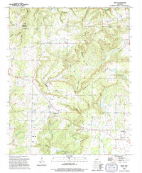
 1994 Barney1994 Print · USGSThe rural borderlands of Faulkner and Cleburne counties are captured here in the mid-1990s, showing a landscape of upland ridges and creek valleys. Genealogists and local historians can locate several family landmarks and houses of worship, such as Mt Pleasant Ch, Brown Cem, and the old crossroads at Enders.
 - 1994 Map of Rose Bud
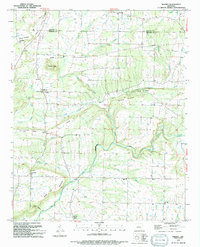
 1994 Rose Bud1994 Print · USGSIn the hills of northern Arkansas during the 1990s, the community of Rose Bud sits at the intersection of three counties. Researchers can trace family roots through numerous landmarks like Rose Bud High Sch, St Marys Ch, and the Starkey Cem.
 - 1994 Map of Guy
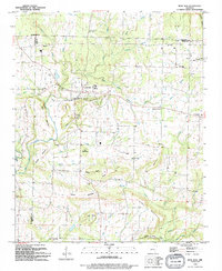
 1994 Guy1994 Print · USGSThe northern reaches of Faulkner County are shown here in the mid-1990s, centering on the small community of Guy. Genealogists and local historians can trace family roots through several legacy sites like Copperas Springs Cem, G W Perkins School, and New Home Ch.
End of results
Showing maps 1-6 of 6
Top cities of Cleburne County
- Heber Springs historical maps
- Greers Ferry historical maps
- Quitman historical maps
- Concord historical maps
- Higden historical maps
Frequently asked questions
- What are the different types of historical maps available for Cleburne County?
- What is the oldest map of Cleburne County?
- Where can I purchase historical maps of Cleburne County for my home or office?
- Where can I download high-res historical maps of Cleburne County?
- Are there historical topographic maps available for Cleburne County?
- Is there historical aerial imagery available for Cleburne County?
- Where are historical maps of Cleburne County sourced from?