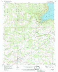
1991 Map of Quitman
USGS Topo · Published 1995About this map
The town of Quitman serves as the focal point of this Cleburne and Van Buren county survey, situated at the junction of Mill Creek and Cadron Creek. The landscape transitions from the river bottoms to significant elevations at Pryor Mountain and Bettis Mountain, while the northeast corner is dominated by the waters of Greers Ferry Lake. The map reveals a deeply rooted rural community, marked by a high density of country churches such as New Bethany Ch, Wesley Chapel, and Flat Rock Ch.
Find a feature on this map
51 named features on this map. Tap any name to fly to it.
Don’t see what you’re looking for? This feature index may not catch every label — zoom into the map to look around manually.
Map Details
Editions of this 1991 Quitman Map
This is the sole edition of this map. No revisions or reprints were ever made.
Other maps of this area

1892 · Mountain View
USGS Topo · 1:125,000

1894 · Mountain View
USGS Topo · 1:125,000

1956 · Russellville
USGS Topo · 1:250,000

1961 · Bee Branch
USGS Topo · 1:62,500

1961 · Morganton
USGS Topo · 1:24,000

1961 · Guy
USGS Topo · 1:24,000

1963 · Rose Bud
USGS Topo · 1:24,000

1963 · Quitman
USGS Topo · 1:24,000
1963 · Barney
USGS Topo · 1:24,000
1963 · Heber Springs
USGS Topo · 1:24,000