
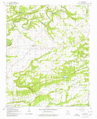
1961 Map of Guy
USGS Topo · Published 1966About this map
Guy serves as the central hub for this rural stretch of Faulkner County in the early 1960s, where small settlements like Batesville and Centerville are connected by State Routes 25 and 225. The landscape is defined by the winding course of Cadron Creek, which carves through the northern hills near Barnett Mountain. Cultural and family history is anchored in numerous community landmarks, including the New Home Sch and several country churches like Soda Valley Ch and Black Fork Ch. The topography reveals a mix of agricultural valley floors and wooded ridges, notably at The Narrows where Mill Creek meets the broader Hardin Valley. Smaller rural pockets are marked by deep-rooted sites such as the Copperas Springs Cem and Old Texas Cem, providing specific points of interest for genealogists tracing local families in the area.
Find a feature on this map
45 named features on this map. Tap any name to fly to it.
Don’t see what you’re looking for? This feature index may not catch every label — zoom into the map to look around manually.
Map Details
Editions of this 1961 Guy Map
2 editions found
Other maps of this area

1956 · Russellville
USGS Topo · 1:250,000

1961 · Conway
USGS Topo · 1:62,500

1961 · Bee Branch
USGS Topo · 1:62,500

1961 · Greenbrier
USGS Topo · 1:24,000

1961 · Bee Branch
USGS Topo · 1:24,000

1961 · Morganton
USGS Topo · 1:24,000

1961 · Damascus
USGS Topo · 1:24,000
1961 · Holland
USGS Topo · 1:24,000

1963 · Quitman
USGS Topo · 1:24,000

1963 · Enola
USGS Topo · 1:24,000