
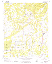
1961 Map of Bee Branch
USGS Topo · Published 1966About this map
Bee Branch and Southside serve as the primary hubs for this 1961 field-checked landscape, where the borders of Van Buren and Conway counties meet. The settlement pattern is defined by upland ridges and narrow creek valleys, with several prominent summits including Harmony Mountain and Culpepper Mountain overseeing the region. Social life in these communities is anchored by numerous rural congregations such as Bethlehem Ch, Hopewell Ch, and Pleasant Valley Ch. The map provides specific genealogical value by documenting locations like Quattlebaum Cem and the Soldier Memorial Cem. The local economy is reflected in features like the Shale Pit and the Southside Schools, while the hydrologic network is dominated by the winding paths of Choctaw Creek and Duke Creek.
Find a feature on this map
39 named features on this map. Tap any name to fly to it.
Don’t see what you’re looking for? This feature index may not catch every label — zoom into the map to look around manually.
Map Details
Editions of this 1961 Bee Branch Map
2 editions found
Other maps of this area

1892 · Marshall
USGS Topo · 1:125,000

1892 · Mountain View
USGS Topo · 1:125,000

1892 · Morrillton
USGS Topo · 1:125,000

1894 · Mountain View
USGS Topo · 1:125,000

1894 · Morrillton
USGS Topo · 1:125,000

1894 · Marshall
USGS Topo · 1:125,000

1901 · Marshall
USGS Topo · 1:125,000

1956 · Russellville
USGS Topo · 1:250,000

1961 · Bee Branch
USGS Topo · 1:62,500

1961 · Morganton
USGS Topo · 1:24,000