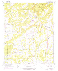
1961 Map of Bee Branch
USGS Topo · Published 1976About this map
Bee Branch and Southside anchor this 1961 study of the northern Arkansas landscape, where the border between Van Buren and Conway counties cuts across the high ridges of the Ozark foothills. The map reveals a community structured around rural gathering points, including the Community Hall near Harmony Mountain and a high density of country churches such as Bethlehem Ch and Steele Hopewell Ch.
Find a feature on this map
41 named features on this map. Tap any name to fly to it.
Don’t see what you’re looking for? This feature index may not catch every label — zoom into the map to look around manually.
Map Details
Editions of this 1961 Bee Branch Map
2 editions found
Other maps of this area

1892 · Marshall
USGS Topo · 1:125,000

1892 · Mountain View
USGS Topo · 1:125,000

1892 · Morrillton
USGS Topo · 1:125,000

1894 · Mountain View
USGS Topo · 1:125,000

1894 · Morrillton
USGS Topo · 1:125,000

1894 · Marshall
USGS Topo · 1:125,000

1901 · Marshall
USGS Topo · 1:125,000

1956 · Russellville
USGS Topo · 1:250,000

1961 · Bee Branch
USGS Topo · 1:62,500

1961 · Bee Branch
USGS Topo · 1:24,000