
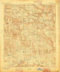
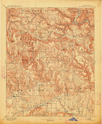
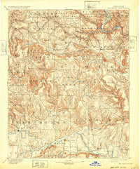
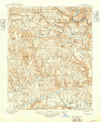
1894 Map of Mountain View
USGS Topo · Published 1894About this map
The White River snakes through the northern reaches of this Arkansas landscape, carving a deep path past Perrins and the bend at Sylamore. Further south, the Mountain View settlement serves as a central hub amidst a series of high ridges and knobs like Candlestick Knob and Panther Mt. The map captures a moment when travel relied on established river crossings, including the Upper Fy. and Lower Fy. on the Little Red River. These ferries connected isolated homesteads and small communities such as Eglantine and Shiloh to the county seats and larger townships. The topography is dominated by the complex drainage systems of the Middle Fork and Devil's Fork, which defined the boundaries of the various land districts and spurred the development of small landings like Millers Point and Stevens Point.
Find a feature on this map
54 named features on this map. Tap any name to fly to it.
Don’t see what you’re looking for? This feature index may not catch every label — zoom into the map to look around manually.
Map Details
Editions of this 1894 Mountain View Map
5 editions found
Other maps of this area

1890 · Batesville
USGS Topo · 1:125,000

1890 · Mountain Home
USGS Topo · 1:125,000

1891 · Mountain Home
USGS Topo · 1:125,000

1891 · Batesville
USGS Topo · 1:125,000

1892 · Marshall
USGS Topo · 1:125,000

1892 · Mountain View
USGS Topo · 1:125,000

1892 · Morrillton
USGS Topo · 1:125,000

1893 · Yellville
USGS Topo · 1:125,000

1894 · Morrillton
USGS Topo · 1:125,000

1894 · Mountain Home
USGS Topo · 1:125,000