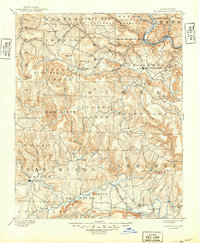
1894 Map of Mountain View
USGS Topo · Published 1949About this map
Mountain View stands as a focal point in this 1894 survey of north-central Arkansas, a landscape defined by the winding course of the White River and the rugged topography of the Ozarks. The map reveals a frontier-era network of water crossings essential to regional commerce, including Greers Fy, Cases FY, and Wilsons Fd. This period was characterized by small, isolated communities like Eglantine, Shiloh, and the simply named Settlement, often situated near dependable water sources such as Sylamore Creek or the Middle Fork.
Find a feature on this map
92 named features on this map. Tap any name to fly to it.
Don’t see what you’re looking for? This feature index may not catch every label — zoom into the map to look around manually.
Map Details
Editions of this 1894 Mountain View Map
5 editions found
Other maps of this area

1890 · Batesville
USGS Topo · 1:125,000

1890 · Mountain Home
USGS Topo · 1:125,000

1891 · Mountain Home
USGS Topo · 1:125,000

1891 · Batesville
USGS Topo · 1:125,000

1892 · Marshall
USGS Topo · 1:125,000

1892 · Mountain View
USGS Topo · 1:125,000

1892 · Morrillton
USGS Topo · 1:125,000

1893 · Yellville
USGS Topo · 1:125,000

1894 · Mountain View
USGS Topo · 1:125,000

1894 · Morrillton
USGS Topo · 1:125,000