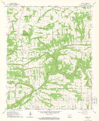
1963 Map of Barney
USGS Topo · Published 1964About this map
The East Fork Cadron Creek carves a winding path through this portion of Central Arkansas, defining the landscape between the Cleburne County and Faulkner County line. Small farming communities such as Enders, Enola, and Mount Vernon are connected by a network of rural roads, showcasing a mid-century settlement pattern focused on localized church and school centers. The terrain is marked by prominent ridges and hills, including Benton Mountain and Beckette Mountain, with the Buffalo Hump Lookout Tower providing a strategic vantage point over the timbered ridges.
Find a feature on this map
42 named features on this map. Tap any name to fly to it.
Don’t see what you’re looking for? This feature index may not catch every label — zoom into the map to look around manually.
Map Details
Editions of this 1963 Barney Map
2 editions found
Other maps of this area

1956 · Russellville
USGS Topo · 1:250,000

1961 · Conway
USGS Topo · 1:62,500

1961 · Bee Branch
USGS Topo · 1:62,500

1961 · Morganton
USGS Topo · 1:24,000

1961 · Guy
USGS Topo · 1:24,000
1961 · Holland
USGS Topo · 1:24,000

1963 · Rose Bud
USGS Topo · 1:24,000

1963 · Quitman
USGS Topo · 1:24,000

1963 · Enola
USGS Topo · 1:24,000

1963 · Mount Vernon
USGS Topo · 1:24,000