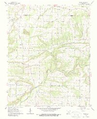
1963 Map of Barney
USGS Topo · Published 1988About this map
Benton Mountain and White Oak Mountain dominate this part of the Arkansas landscape, where the East Fork Cadron Creek winds through the hills between the settlements of Barney and Enders. The map reveals a rural community structured around small country churches and family burial grounds, including Mt Pleasant Ch and the Mortar Creek Cem. High points such as Buffalo Hump and Beckette Mountain define the topography, with a Lookout Tower positioned for fire watch over the timbered ridges. Agricultural activity is concentrated along the creek bottoms and on flatter reaches like Fairview Ridge, while more industrial footprints are seen at the Gas Well in the northern section of the quadrangle. This 1963 field-checked survey preserves the road networks and rural property divisions of Faulkner County during the mid-20th century.
Find a feature on this map
42 named features on this map. Tap any name to fly to it.
Don’t see what you’re looking for? This feature index may not catch every label — zoom into the map to look around manually.
Map Details
Editions of this 1963 Barney Map
2 editions found
Other maps of this area

1956 · Russellville
USGS Topo · 1:250,000

1961 · Conway
USGS Topo · 1:62,500

1961 · Bee Branch
USGS Topo · 1:62,500

1961 · Morganton
USGS Topo · 1:24,000

1961 · Guy
USGS Topo · 1:24,000
1961 · Holland
USGS Topo · 1:24,000

1963 · Rose Bud
USGS Topo · 1:24,000

1963 · Quitman
USGS Topo · 1:24,000

1963 · Enola
USGS Topo · 1:24,000

1963 · Mount Vernon
USGS Topo · 1:24,000