1960s Maps of Clarkedale, Arkansas
Explore 3 historic maps of Clarkedale from the 1960s. These maps offer a rare glimpse into what life looked like during the 1960s — showing old roads, neighborhoods, homes, and landmarks that have changed or disappeared over time.
Whether you're researching your family's past, planning a metal detecting trip, or studying how Clarkedale's landscape evolved across the 1960s, these high-resolution maps are a powerful tool for exploring the history of this region.
- Focus on a specific era: All maps on this page are from the 1960s, giving you a focused view of this time period.
- See what’s changed: Compare century-old streets, trails, and buildings to today's modern landscape using overlays and satellite layers.
- Research with precision: Use these maps for genealogy, historical research, land use analysis, or educational projects.
- View, download, or print: Maps are fully viewable online in high resolution, and can be downloaded or printed for your own records.
Start exploring Clarkedale's history through authentic maps from the 1960s. This is your window into the past.
Clarkedale, AR maps
(3)- 1961 Map of Jericho, 1963 Print
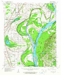 1961 Jericho1963 Print · USGSThe Mississippi River delta at the start of the 1960s reveals a world of island farming and rail-side settlements along the Arkansas-Tennessee border. Genealogists can trace family roots through numerous local landmarks, including Jericho, Clarkedale, and the St Paul School and Church.
 - 1962 Map of Jericho
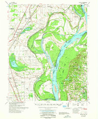 1962 Jericho1962 Print · USGSThe riverfront border of Arkansas and Tennessee is captured here in the early sixties, showing a landscape shaped by the Mississippi River. Genealogists and local historians can trace family roots through sites like Jericho, James Mill, and Lambethville, or locate rural landmarks such as Pecan Point Cem and the Shawnee Sch.
 - 1963 Map of Heafer, 1976 Print
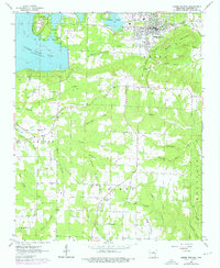 1963 Heafer1976 Print · USGSHeber Springs and the surrounding Cleburne County hills are shown during a period of growth as the Greers Ferry Lake shoreline stabilized. Researchers can locate rural landmarks like Mt Devonshire Ch, Palestine Cem, and the Old Railroad Grade.
End of results
Showing maps 1-3 of 3
Top cities near Clarkedale
- Memphis historical maps
- West Memphis historical maps
- Marion historical maps
- Marked Tree historical maps
- Earle historical maps
- Tyronza historical maps
See more
Frequently asked questions
- What are the different types of historical maps available for Clarkedale?
- What is the oldest map of Clarkedale?
- Where can I purchase historical maps of Clarkedale for my home or office?
- Where can I download high-res historical maps of Clarkedale?
- Are there historical topographic maps available for Clarkedale?
- Is there historical aerial imagery available for Clarkedale?
- Where are historical maps of Clarkedale sourced from?