1963 Map of Heafer
USGS Topo · Published 1976About this map
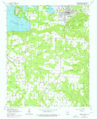
Heber Springs serves as the primary hub of this Arkansas landscape, where the developing shoreline of Greers Ferry Lake meets the established agricultural and timbered uplands. The presence of an Old Railroad Grade north of Round Mountain points to a transition in local transportation, while the numerous rural churches such as Mt Olive Ch, Mt Devonshire Ch, and Friendship Ch reflect the distributed social network of Cleburne County.
Find a feature on this map
53 named features on this map. Tap any name to fly to it.
Don’t see what you’re looking for? This feature index may not catch every label — zoom into the map to look around manually.
Map Details
Editions of this 1963 Heafer Map
This is the sole edition of this map. No revisions or reprints were ever made.
Other maps of this area

1916 · Memphis
USGS Topo · 1:62,500

1925 · Memphis
USGS Topo · 1:48,000

1927 · Memphis
USGS Topo · 1:62,500

1931 · Jericho
USGS Topo · 1:62,500

1939 · Jericho
USGS Topo · 1:62,500
1939 · Edmondson
USGS Topo · 1:62,500
1939 · Memphis
USGS Topo · 1:62,500

1940 · Deckerville
USGS Topo · 1:62,500

1952 · Jericho
USGS Topo · 1:62,500

1953 · Memphis
USGS Topo · 1:250,000