1980s Maps of Hickory Ridge, Arkansas
Explore 4 historic maps of Hickory Ridge from the 1980s. These maps offer a rare glimpse into what life looked like during the 1980s — showing old roads, neighborhoods, homes, and landmarks that have changed or disappeared over time.
Whether you're researching your family's past, planning a metal detecting trip, or studying how Hickory Ridge's landscape evolved across the 1980s, these high-resolution maps are a powerful tool for exploring the history of this region.
- Focus on a specific era: All maps on this page are from the 1980s, giving you a focused view of this time period.
- See what’s changed: Compare century-old streets, trails, and buildings to today's modern landscape using overlays and satellite layers.
- Research with precision: Use these maps for genealogy, historical research, land use analysis, or educational projects.
- View, download, or print: Maps are fully viewable online in high resolution, and can be downloaded or printed for your own records.
Start exploring Hickory Ridge's history through authentic maps from the 1980s. This is your window into the past.
Hickory Ridge, AR maps
(4)- 1980 Map of Beedeville
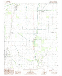
 1980 Beedeville1980 Print · USGSBeedeville and the surrounding delta wetlands were undergoing significant hydrological shifts by the 1980s. Genealogists and local historians can trace family roots through the Citizenship Ch and several rural burial grounds like Eight Mile Cem and Jones Cem.
 - 1984 Map of Hickory Ridge, 1985 Print
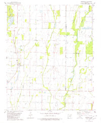
 1984 Hickory Ridge1985 Print · USGSThe Arkansas Delta lowlands in the early eighties reveal a landscape of managed waterways and rural rail stops. Genealogists and researchers can trace the agricultural layout of Hickory Ridge, Fisher, and the Poinsett Co Cross Co line.
 - 1986 Map of Searcy
 1986 Searcy1986 Print · USGSWhite County and its neighbors reached a period of established agricultural and rail prosperity by the mid-1980s. Local researchers can trace the routes of the Missouri Pacific RR and locate rural communities like Velvet Ridge, Sunnydale, and Cotton Plant.2 unique versions available
 - 1986 Map of Memphis West
 1986 Memphis West1986 Print · USGSThe Mississippi River delta and the rise of Crowleys Ridge define this mid-1980s look at the Mid-South. Researchers can trace the development of West Memphis and Marion or locate landmarks like Crittenden Mem Cem and Village Creek State Park.2 unique versions available
End of results
Showing maps 1-4 of 4
Top cities near Hickory Ridge
- Wynne historical maps
- Newport historical maps
- McCrory historical maps
- Weiner historical maps
- Fisher historical maps
- Beedeville historical maps
See more
Frequently asked questions
- What are the different types of historical maps available for Hickory Ridge?
- What is the oldest map of Hickory Ridge?
- Where can I purchase historical maps of Hickory Ridge for my home or office?
- Where can I download high-res historical maps of Hickory Ridge?
- Are there historical topographic maps available for Hickory Ridge?
- Is there historical aerial imagery available for Hickory Ridge?
- Where are historical maps of Hickory Ridge sourced from?