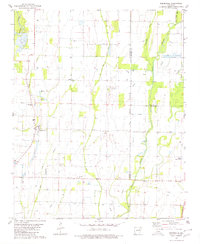
1980 Map of Beedeville
USGS Topo · Published 1980About this map
The low-lying wetlands and agricultural drainages of the Arkansas Delta define this 1980 survey, where the town of Beedeville sits at a crossroads amidst a complex network of waterways. The landscape is dominated by the Cache River and Bayou De View, with human intervention visible through the extensive channelization of Cow Lake Ditch and Flag Slough Ditch. This era shows a community deeply tied to the land, featuring localized landmarks such as the Fish Hatchery and several rural burial grounds including Eight Mile Cem, Walker Cem, and Jones Cem. The map provides a precise look at the intersection of three counties—Jackson, Poinsett, and Cross—along the Fifth Principal Meridian. Traces of local social life are anchored by Citizenship Ch, while a small Landing Strip and the Lateral road network reflect the region's mid-century aviation and infrastructure development.
Find a feature on this map
21 named features on this map. Tap any name to fly to it.
Don’t see what you’re looking for? This feature index may not catch every label — zoom into the map to look around manually.
Map Details
Editions of this 1980 Beedeville Map
This is the sole edition of this map. No revisions or reprints were ever made.
Other maps of this area

1935 · Tuckerman
USGS Topo · 1:62,500

1939 · Vanndale
USGS Topo · 1:62,500

1939 · Weiner
USGS Topo · 1:62,500

1940 · Tilton
USGS Topo · 1:62,500

1953 · Memphis
USGS Topo · 1:250,000

1956 · Memphis
USGS Topo · 1:250,000

1956 · Tilton
USGS Topo · 1:62,500

1958 · Vanndale
USGS Topo · 1:62,500

1959 · Weiner
USGS Topo · 1:62,500

1960 · Weiner
USGS Topo · 1:62,500