
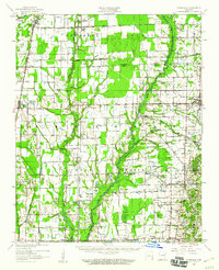
1958 Map of Vanndale
USGS Topo · Published 1958About this map
L'Anguille River meanders through the central lowlands of this 1958 survey, marking the transition between the agricultural plains of Poinsett County and Cross County. The landscape is defined by an intricate network of waterways, including Bayou De View, Caney Creek, and the St Louis Southwestern RR line which services the rail towns of Fisher and Hickory Ridge. This era shows a community deeply rooted in its local institutions, evidenced by the numerous country churches such as Manns Ch, Palmer Ch, and the combined Tilton Sch & Ch. A distinct pattern of drainage ditches and flumes across the terrain suggests the intensive water management required for the region's mid-century farming operations. Settlement is concentrated along the rail corridors and major road crossings, with Vanndale and Cherry Valley serving as primary local hubs.
Find a feature on this map
53 named features on this map. Tap any name to fly to it.
Don’t see what you’re looking for? This feature index may not catch every label — zoom into the map to look around manually.
Map Details
Editions of this 1958 Vanndale Map
2 editions found
Other maps of this area

1935 · Tuckerman
USGS Topo · 1:62,500

1939 · Vanndale
USGS Topo · 1:62,500

1939 · Weiner
USGS Topo · 1:62,500

1939 · Wynne
USGS Topo · 1:62,500

1939 · Hunter
USGS Topo · 1:62,500

1940 · Princedale
USGS Topo · 1:62,500

1940 · Whitmore
USGS Topo · 1:62,500

1940 · Dee
USGS Topo · 1:62,500

1940 · Tilton
USGS Topo · 1:62,500

1953 · Memphis
USGS Topo · 1:250,000