
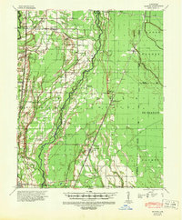
1939 Map of Hunter
USGS Topo · Published 1942About this map
Hunter and the surrounding Arkansas lowlands are defined here by a dense network of watercourses and early 20th-century rail lines. The confluence of the St Louis Southwestern and the Chicago Rock Island & Pacific railroads at Hunter made it a vital junction for the timber and agricultural industries of Woodruff County. To the north, the town of Fairoaks serves as another key crossing point, while smaller settlements like Hillemann and De View are scattered throughout the floodplains of De View Bayou and Cache Bayou. Numerous rural institutions anchor the landscape, including the Hillmann Jr High Sch and several combined church and burial sites such as Whitehall Ch & Cem and Long Grove Ch & Cem. The map reveals a land heavily managed for drainage, with many small bayous and creeks like Caney Creek and Nubbin Creek crisscrossing the flat terrain between the rail corridors.
Find a feature on this map
65 named features on this map. Tap any name to fly to it.
Don’t see what you’re looking for? This feature index may not catch every label — zoom into the map to look around manually.
Map Details
Editions of this 1939 Hunter Map
2 editions found
Other maps of this area

1935 · Augusta
USGS Topo · 1:62,500

1935 · Gregory
USGS Topo · 1:62,500

1939 · Vanndale
USGS Topo · 1:62,500

1939 · Wynne
USGS Topo · 1:62,500

1940 · Brinkley
USGS Topo · 1:62,500

1940 · Marianna
USGS Topo · 1:62,500

1940 · Tilton
USGS Topo · 1:62,500

1941 · De Valls Bluff
USGS Topo · 1:62,500

1948 · Helena
USGS Topo · 1:250,000

1950 · Helena
USGS Topo · 1:250,000