
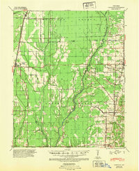
1939 Map of Vanndale
USGS Topo · Published 1941About this map
Crowleys Ridge rises above the lowlands of the Mississippi Alluvial Plain, serving as the dominant geographic feature for this late 1930s survey of eastern Arkansas. The terrain is defined by a complex drainage system where the L'Anguille River and its many tributaries, such as Wolf Cr and Prairie Cr, weave through the landscape. This era shows a rural society supported by a network of local schools including Mersman Sch, Rose Sch, and Walker Sch. Settlement patterns are closely tied to the regional rail lines, with the St Louis Southwestern Ry serving Fisher and Hickory Ridge, while the Missouri Pacific RR connects Cherry Valley and Vanndale. The map provides a clear look at the agricultural footprint of Cross and Poinsett counties before modern industrial farming consolidated these smaller rural communities and school districts.
Find a feature on this map
29 named features on this map. Tap any name to fly to it.
Don’t see what you’re looking for? This feature index may not catch every label — zoom into the map to look around manually.
Map Details
Editions of this 1939 Vanndale Map
2 editions found
Other maps of this area

1935 · Tuckerman
USGS Topo · 1:62,500

1939 · Weiner
USGS Topo · 1:62,500

1939 · Wynne
USGS Topo · 1:62,500

1939 · Hunter
USGS Topo · 1:62,500

1940 · Princedale
USGS Topo · 1:62,500

1940 · Whitmore
USGS Topo · 1:62,500

1940 · Dee
USGS Topo · 1:62,500

1940 · Tilton
USGS Topo · 1:62,500

1953 · Memphis
USGS Topo · 1:250,000

1956 · Memphis
USGS Topo · 1:250,000