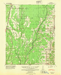
1939 Map of Vanndale
USGS Topo · Published 1948About this map
The L'Anguille River winds through the heart of Cross County, defining a landscape shaped by both natural drainage and early industrial infrastructure. In this late 1930s survey, the intersection of the St Louis Southwestern and Missouri Pacific railroads anchors the regional economy, connecting settlements like Hickory Ridge, Cherry Valley, and Vanndale. The map reveals a deeply rooted rural community, evidenced by a network of localized institutions such as Mersman Sch, Red Sch, and Rose Sch, alongside the Union Grove Cem. Beyond the rail corridors, the terrain is marked by significant hydrological features including the Collecting Ditch and Bayou De View, illustrating the extensive efforts to manage the wetlands for agriculture. This topography provides a clear view of the Poinsett and Cross County borderlands before modern consolidation changed the rural school and rail landscape.
Find a feature on this map
24 named features on this map. Tap any name to fly to it.
Don’t see what you’re looking for? This feature index may not catch every label — zoom into the map to look around manually.
Map Details
Editions of this 1939 Vanndale Map
2 editions found
Other maps of this area

1935 · Tuckerman
USGS Topo · 1:62,500

1939 · Vanndale
USGS Topo · 1:62,500

1939 · Weiner
USGS Topo · 1:62,500

1939 · Wynne
USGS Topo · 1:62,500

1939 · Hunter
USGS Topo · 1:62,500

1940 · Princedale
USGS Topo · 1:62,500

1940 · Whitmore
USGS Topo · 1:62,500

1940 · Dee
USGS Topo · 1:62,500

1940 · Tilton
USGS Topo · 1:62,500

1953 · Memphis
USGS Topo · 1:250,000