1970s Maps of Dallas County, Arkansas
Explore 9 historic maps of Dallas County from the 1970s. These maps offer a rare glimpse into what life looked like during the 1970s — showing old roads, neighborhoods, homes, and landmarks that have changed or disappeared over time.
Whether you're researching your family's past, planning a metal detecting trip, or studying how Dallas County's landscape evolved across the 1970s, these high-resolution maps are a powerful tool for exploring the history of this region.
- Focus on a specific era: All maps on this page are from the 1970s, giving you a focused view of this time period.
- See what’s changed: Compare century-old streets, trails, and buildings to today's modern landscape using overlays and satellite layers.
- Research with precision: Use these maps for genealogy, historical research, land use analysis, or educational projects.
- View, download, or print: Maps are fully viewable online in high resolution, and can be downloaded or printed for your own records.
Start exploring Dallas County's history through authentic maps from the 1970s. This is your window into the past.
Dallas County, AR maps
(9)- 1971 Map of Tates Bluff, 1973 Print
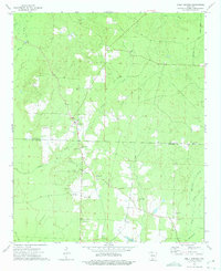
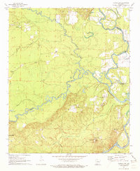 1971 Tates Bluff1973 Print · USGSThe Ouachita and Little Missouri rivers converge here in the early 1970s, forming a complex network of wetlands and river bluffs. Genealogists can locate several family-named landmarks and burial grounds, including Easley Cem, Kansas Cem, and the rural community of Vaden.2 unique versions available
 - 1971 Map of Sparkman, 1973 Print
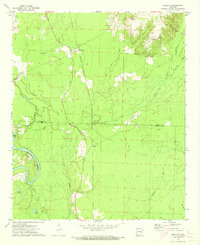
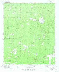
 1971 Sparkman1973 Print · USGSDallas County in the early 1970s shows a landscape of timber-lined creeks and small railroad towns. Researchers can trace family sites at Holeman Cem, visit the local congregation at Mt Carmel Ch, or follow the Chicago and Rock Island Pacific tracks through Sparkman.2 unique versions available
 - 1971 Map of Ouachita, 1973 Print
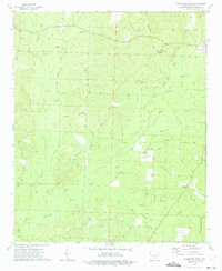
 1971 Ouachita1973 Print · USGSThe river bottomlands of South Arkansas are captured here in the early 1970s, showing a landscape defined by timber and water. You can trace the path of an abandoned railroad line or locate family landmarks like Smead Ch and the Brazeale Cem.2 unique versions available
 - 1971 Map of Sparkman NW, 1973 Print
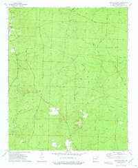
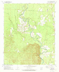 1971 Sparkman NW1973 Print · USGSThe Ouachita River valley in the early 1970s reveals a landscape of winding oxbows and timbered bottomlands along the Clark and Dallas county line. Genealogists and local historians can trace rural settlements like Fairview and Shakertown or find family landmarks at Rock Springs Church and Nix Ferry.2 unique versions available
 - 1973 Map of Holly Springs, 1975 Print
 1973 Holly Springs1975 Print · USGSThe Holly Springs area of south-central Arkansas is documented here during the early seventies, showing a landscape defined by creek valleys and timber. Researchers can locate several rural landmarks including Holly Springs Cem, the Holly Springs Lookout Tower, and White Oak Ch.2 unique versions available
 - 1973 Map of Hopeville, 1975 Print
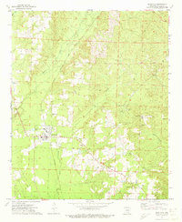
 1973 Hopeville1975 Print · USGSThe borderlands of Dallas, Ouachita, and Calhoun counties are captured here in the early seventies, a landscape of rural crossroads and timbered creek bottoms. Genealogists can locate family landmarks like Stevenson Cem, Oak Grove Ch, and the settlement of Hopeville.2 unique versions available
 - 1973 Map of Princeton West, 1975 Print
 1973 Princeton West1975 Print · USGSThe rural stretches of Dallas County come into focus during the early 1970s, showing a landscape shaped by bottomland sloughs and country churches. Genealogists can trace family roots through Henderson Cem and Herring Cem or locate the community hubs of Mt Zion Ch and Princeton.2 unique versions available
 - 1973 Map of Princeton East, 1975 Print
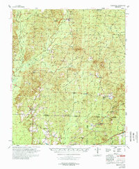
 1973 Princeton East1975 Print · USGSDallas County was a landscape of timber and rural community in the 1970s, as seen through this detailed survey. Researchers can trace family sites at Princeton Cem and Liberty Cem, or follow old paths like Eagle Tram Road and Billy Jones Road.2 unique versions available
 - 1978 Map of Princeton
 1978 Princeton1978 Print · USGSSouth Arkansas rural life is captured here in the late 1970s as timber and rail lines defined the local economy. Researchers can trace family roots at Princeton Cem and Macedonia Ch or locate industrial sites like the Fish Hatchery and numerous Gravel Pits.
End of results
Showing maps 1-9 of 9
Top cities of Dallas County
Frequently asked questions
- What are the different types of historical maps available for Dallas County?
- What is the oldest map of Dallas County?
- Where can I purchase historical maps of Dallas County for my home or office?
- Where can I download high-res historical maps of Dallas County?
- Are there historical topographic maps available for Dallas County?
- Is there historical aerial imagery available for Dallas County?
- Where are historical maps of Dallas County sourced from?