1940s Maps of Faulkner County, Arkansas
Explore 2 historic maps of Faulkner County from the 1940s. These maps offer a rare glimpse into what life looked like during the 1940s — showing old roads, neighborhoods, homes, and landmarks that have changed or disappeared over time.
Whether you're researching your family's past, planning a metal detecting trip, or studying how Faulkner County's landscape evolved across the 1940s, these high-resolution maps are a powerful tool for exploring the history of this region.
- Focus on a specific era: All maps on this page are from the 1940s, giving you a focused view of this time period.
- See what’s changed: Compare century-old streets, trails, and buildings to today's modern landscape using overlays and satellite layers.
- Research with precision: Use these maps for genealogy, historical research, land use analysis, or educational projects.
- View, download, or print: Maps are fully viewable online in high resolution, and can be downloaded or printed for your own records.
Start exploring Faulkner County's history through authentic maps from the 1940s. This is your window into the past.
Faulkner County, AR maps
(2)- 1941 Map of Olmstead, 1945 Print
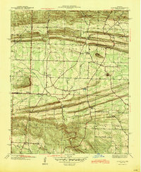 1941 Olmstead1945 Print · USGSNorth of Little Rock in the early 1940s, this area was a network of bayous and ridges punctuated by rural crossroads and family homesteads. Genealogists and local historians can trace legacy sites like Tates Mill, Sumner Cem, and several country meeting houses including Zion Hill Ch and Harmony Ch.
 - 1943 Map of Pinnacle Mtn, 1946 Print
 1943 Pinnacle Mtn1946 Print · USGSPulaski County at the end of the war shows a landscape of river-bend settlements and rising ridges. Genealogists can trace family names at the Brimmette Cem and Pankey Cem or locate old school sites like Round Hill Sch.
End of results
Showing maps 1-2 of 2
Top cities of Faulkner County
- Conway historical maps
- Greenbrier historical maps
- Vilonia historical maps
- Mayflower historical maps
- Wooster historical maps
- Holland historical maps
See more
Frequently asked questions
- What are the different types of historical maps available for Faulkner County?
- What is the oldest map of Faulkner County?
- Where can I purchase historical maps of Faulkner County for my home or office?
- Where can I download high-res historical maps of Faulkner County?
- Are there historical topographic maps available for Faulkner County?
- Is there historical aerial imagery available for Faulkner County?
- Where are historical maps of Faulkner County sourced from?