1950s Maps of Faulkner County, Arkansas
Explore 7 historic maps of Faulkner County from the 1950s. These maps offer a rare glimpse into what life looked like during the 1950s — showing old roads, neighborhoods, homes, and landmarks that have changed or disappeared over time.
Whether you're researching your family's past, planning a metal detecting trip, or studying how Faulkner County's landscape evolved across the 1950s, these high-resolution maps are a powerful tool for exploring the history of this region.
- Focus on a specific era: All maps on this page are from the 1950s, giving you a focused view of this time period.
- See what’s changed: Compare century-old streets, trails, and buildings to today's modern landscape using overlays and satellite layers.
- Research with precision: Use these maps for genealogy, historical research, land use analysis, or educational projects.
- View, download, or print: Maps are fully viewable online in high resolution, and can be downloaded or printed for your own records.
Start exploring Faulkner County's history through authentic maps from the 1950s. This is your window into the past.
Faulkner County, AR maps
(7)- 1953 Map of Cato
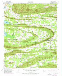 1953 Cato1953 Print · USGSThe hills of central Arkansas meet heavy military and rural history during the mid-fifties near the Faulkner-Pulaski line. Trace the borders of (Former Camp J T Robinson) and locate local landmarks like Blue Hill School and Cato Pentecostal Church.4 unique versions available
 - 1953 Map of Mayflower, 1957 Print
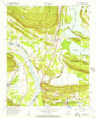 1953 Mayflower1957 Print · USGSThe Arkansas River valley at mid-century shows a landscape defined by military reservations and rural settlement patterns. Genealogists and local historians can trace the foundations of Mayflower and find historic sites like White City Church and Mayflower Cemetery.5 unique versions available
 - 1954 Map of Pinnacle Mountain, 1957 Print
 1954 Pinnacle Mountain1957 Print · USGSThe foothills of the Ouachitas meet the Arkansas River mid-century, where industry and rural life intersect. Genealogists and historians can trace family locations near the Maumelle Ordnance Works, Joe T Robinson School, and Natural Steps.
 - 1954 Map of Olmstead, 1957 Print
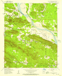
 1954 Olmstead1957 Print · USGSPulaski County at the dawn of the jet age shows a rural landscape of ridges and bayous meeting the new military installations. Genealogists can locate family sites like Mount Valley Cemetery, Tates Mill, and the Bayou Mete School.4 unique versions available
 - 1955 Map of Little Rock, 1978 Print
 1955 Little Rock1978 Print · USGSCentral Arkansas in the mid-fifties exhibits a landscape of growing cities, massive military installations, and mountain reservoirs. Genealogists and historians can trace the industrial Bauxite Mines, regional rail lines, and local landmarks like Antioch Church.
 - 1956 Map of Little Rock
 1956 Little Rock1956 Print · USGSCentral Arkansas in the mid-fifties shows a landscape defined by burgeoning military bases and the timber-and-mineral wealth of the Ouachitas. Genealogists and researchers can trace old rail lines like the Missouri Pacific and find established communities such as Bauxite, Sheridan, and Mabelvale.
 - 1956 Map of Russellville
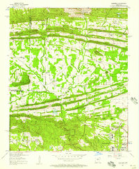
 1956 Russellville1956 Print · USGSThe Arkansas River valley and the surrounding Boston Mountains are captured here in the mid-fifties, showing a landscape of small timber towns and new reservoirs. Genealogists can trace family roots through upland settlements like Pelsor and Witts Springs or locate the campus of Arkansas Polytechnic College.2 unique versions available
End of results
Showing maps 1-7 of 7
Top cities of Faulkner County
- Conway historical maps
- Greenbrier historical maps
- Vilonia historical maps
- Mayflower historical maps
- Wooster historical maps
- Holland historical maps
See more
Frequently asked questions
- What are the different types of historical maps available for Faulkner County?
- What is the oldest map of Faulkner County?
- Where can I purchase historical maps of Faulkner County for my home or office?
- Where can I download high-res historical maps of Faulkner County?
- Are there historical topographic maps available for Faulkner County?
- Is there historical aerial imagery available for Faulkner County?
- Where are historical maps of Faulkner County sourced from?