1930s Maps of Franklin County, Arkansas
Explore 3 historic maps of Franklin County from the 1930s. These maps offer a rare glimpse into what life looked like during the 1930s — showing old roads, neighborhoods, homes, and landmarks that have changed or disappeared over time.
Whether you're researching your family's past, planning a metal detecting trip, or studying how Franklin County's landscape evolved across the 1930s, these high-resolution maps are a powerful tool for exploring the history of this region.
- Focus on a specific era: All maps on this page are from the 1930s, giving you a focused view of this time period.
- See what’s changed: Compare century-old streets, trails, and buildings to today's modern landscape using overlays and satellite layers.
- Research with precision: Use these maps for genealogy, historical research, land use analysis, or educational projects.
- View, download, or print: Maps are fully viewable online in high resolution, and can be downloaded or printed for your own records.
Start exploring Franklin County's history through authentic maps from the 1930s. This is your window into the past.
Franklin County, AR maps
(3)- 1934 Map of Booneville
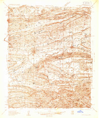 1934 Booneville1934 Print · USGSLogan County during the mid-1930s reveals a network of small Arkansas settlements and mountain ridges connected by the Rock Island line. Researchers can trace family history through sites like the State Sanitarium, Wesley Chapel, and the Rocky Springs Cem.2 unique versions available
 - 1939 Map of Watalula
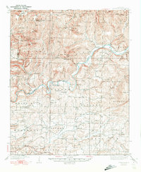 1939 Watalula1939 Print · USGSFranklin and Crawford counties are shown here in the mid-thirties as a landscape of isolated mountain ridges and river-valley settlements. Trace local history through the Wire Road, remote country churches like Low Gap Church, and family cemeteries including Brewer Cem and Harris Cem.3 unique versions available
 - 1939 Map of Booneville
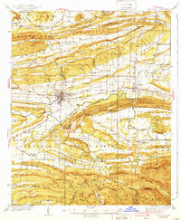 1939 Booneville1939 Print · USGSThe Logan County countryside thrives in the 1930s as a crossroads of the Rock Island railroad and the Petit Jean Creek valley. Genealogists can locate family landmarks like Harvel Cem, the State Sanatorium, and local schools including Shady Grove Sch.3 unique versions available
End of results
Showing maps 1-3 of 3
Top cities of Franklin County
- Ozark historical maps
- Charleston historical maps
- Altus historical maps
- Branch historical maps
- Denning historical maps
- Wiederkehr Village historical maps
Frequently asked questions
- What are the different types of historical maps available for Franklin County?
- What is the oldest map of Franklin County?
- Where can I purchase historical maps of Franklin County for my home or office?
- Where can I download high-res historical maps of Franklin County?
- Are there historical topographic maps available for Franklin County?
- Is there historical aerial imagery available for Franklin County?
- Where are historical maps of Franklin County sourced from?